Bernhardswald geodata
Bernhardswald (Bavaria) is a seat of a fourth-order administrative division; located in Germany in Europe/Berlin (GMT+2) time zone. With population of 5,596 people, there are 2596 cities with bigger population in this country. Compared to other cities in Germany, 81.8% of cities are located further ↑North; 85.2% of cities are located further ←West and 83% of cities have lower elevation than Bernhardswald. Note1
Administrative division(s):
- Level 1: Bavaria
- Level 2: Upper Palatinate
- Level 3: Landkreis Regensburg
- Level 4: Bernhardswald


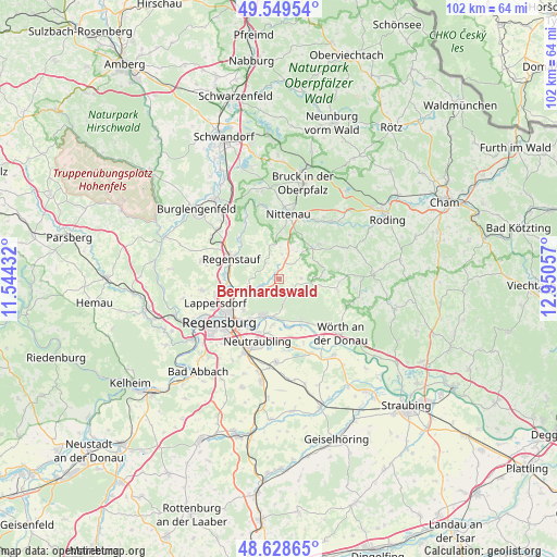
Bernhardswald GPS coordinates[2]
49° 5' 28.428" North, 12° 14' 50.784" East
| Map corner | latitude | longitude |
|---|---|---|
| Upper-left | 49.54954°, | 11.54432° |
| Center: | 49.09123°, | 12.24744° |
| Lower-right: | 48.62865°, | 12.95057° |
| Map W x H: | 102.4×102.4 km | = 63.6×63.6mi |
| max Lat: | 55.01917° ⇑81.8% North |
| Bernhardswald: | 49.09123° |
| min Lat: | ⇓18.2% South 47.40724° |
| min Long | Bernhardswald | max Long |
| 5.92978° | 12.24744° | 14.98853° |
| W 85.2%⇐ | ⇒14.8% E |
Elevation
Elevation of Bernhardswald is 453 m = 1486 ft, and this is 203.9 m = 669 ft above average elevation for this country.
| Max E: |
1256 m = 4121 ft | 17% |
| Bernhardswald | 453 m 1486 ft | |
| Avg. | 249.1 m = 817 ft | |
Min E: |
-5 m = -16 ft | 83% |
See also: Germany elevation on elevation.city.
Geographical zone
Bernhardswald is located in North temperate zone (between Tropic of Cancer and the Arctic Circle). Distance of this North polar circle is 1942.7 km =1207.1 mi to North.| Distance of | km | miles | from Bernhardswald |
|---|---|---|---|
| North Pole | 4548.6 | 2826.4 | to North |
| Arctic Circle | 1942.7 | 1207.1 | to North |
| Tropic Cancer | 2852.5 | 1772.5 | to South |
| Equator | 5458.4 | 3391.7 | to South |


Nearby cities:
15 places around Bernhardswald: (largest is in red/bold)
• Altenthann
3.9 km =2.4 mi,  75°
75°
• Barbing
10.7 km =6.6 mi,  198°
198°
• Brennberg
11.4 km =7.1 mi,  103°
103°
• Donaustauf
7.2 km =4.5 mi,  205°
205°
• Lappersdorf
12.4 km =7.7 mi,  246°
246°
• Neutraubling
12 km =7.5 mi, 196°
• Nittenau
11.5 km =7.1 mi,  7°
7°
• Regenstauf
9.1 km =5.7 mi,  290°
290°
• Reichenbach
12.7 km =7.9 mi,  36°
36°
• Reinhausen
11.9 km =7.4 mi,  235°
235°
• Tegernheim
9.2 km =5.7 mi,  215°
215°
• Tiefenbach
11.8 km =7.3 mi,  27°
27°
• Wald
9.9 km =6.2 mi,  48°
48°
• Wenzenbach
3.9 km =2.4 mi, 243°
• Zeitlarn
10 km =6.2 mi,  261°
261°
Sources, notices
• [Note1] Compared only with cities in Germany existing in our database
• [Src1] Map data: © OpenStreetMap contributors (CC-BY-SA)
• [Src2] Other city data from geonames.org with taken over terms of usage.
• [Src3] Geographical zone / Annual Mean Temperature by Robert A. Rohde @ Wikipedia
