Wattendorf geodata
Wattendorf (Bavaria) is a seat of a fourth-order administrative division; located in Germany in Europe/Berlin (GMT+2) time zone. With population of 694 people, there are 8345 cities with bigger population in this country. Compared to other cities in Germany, 63% of cities are located further ↑North; 68.8% of cities are located further ←West and 91.2% of cities have lower elevation than Wattendorf. Note1
Administrative division(s):
- Level 1: Bavaria
- Level 2: Upper Franconia
- Level 3: Landkreis Bamberg
- Level 4: Wattendorf


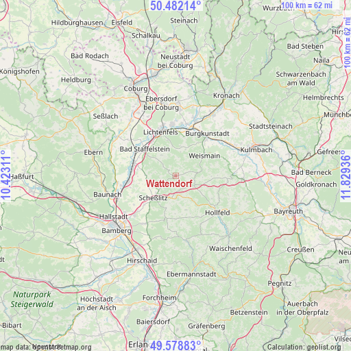
Wattendorf GPS coordinates[2]
50° 1' 57.396" North, 11° 7' 34.428" East
| Map corner | latitude | longitude |
|---|---|---|
| Upper-left | 50.48214°, | 10.42311° |
| Center: | 50.03261°, | 11.12623° |
| Lower-right: | 49.57883°, | 11.82936° |
| Map W x H: | 100.4×100.4 km | = 62.4×62.4mi |
| max Lat: | 55.01917° ⇑63% North |
| Wattendorf: | 50.03261° |
| min Lat: | ⇓37% South 47.40724° |
| min Long | Wattendorf | max Long |
| 5.92978° | 11.12623° | 14.98853° |
| W 68.8%⇐ | ⇒31.2% E |
Elevation
Elevation of Wattendorf is 531 m = 1742 ft, and this is 281.9 m = 925 ft above average elevation for this country.
| Max E: |
1256 m = 4121 ft | 8.8% |
| Wattendorf | 531 m 1742 ft | |
| Avg. | 249.1 m = 817 ft | |
Min E: |
-5 m = -16 ft | 91.2% |
See also: Germany elevation on elevation.city.
Geographical zone
Wattendorf is located in North temperate zone (between Tropic of Cancer and the Arctic Circle). Distance of this North polar circle is 1838.1 km =1142.1 mi to North.| Distance of | km | miles | from Wattendorf |
|---|---|---|---|
| North Pole | 4444 | 2761.4 | to North |
| Arctic Circle | 1838.1 | 1142.1 | to North |
| Tropic Cancer | 2957.2 | 1837.5 | to South |
| Equator | 5563.1 | 3456.7 | to South |


Nearby cities:
15 places around Wattendorf: (largest is in red/bold)
• Altendorf
6.5 km =4 mi,  27°
27°
• Altenkunstadt
13.6 km =8.5 mi,  40°
40°
• Bad Staffelstein
11.8 km =7.3 mi,  310°
310°
• Burgkunstadt
15 km =9.3 mi, 36°
• Ebensfeld
12.6 km =7.8 mi,  287°
287°
• Hochstadt am Main
13.5 km =8.4 mi,  13°
13°
• Königsfeld
10 km =6.2 mi,  163°
163°
• Lichtenfels
13.4 km =8.3 mi,  339°
339°
• Michelau
14.5 km =9 mi,  355°
355°
• Poxdorf
10.7 km =6.6 mi,  181°
181°
• Scheßlitz
9.2 km =5.7 mi,  226°
226°
• Stadelhofen
6.1 km =3.8 mi,  122°
122°
• Weismain
10 km =6.2 mi,  54°
54°
• Wonsees
13.9 km =8.6 mi, 116°
• Zapfendorf
13.9 km =8.6 mi,  263°
263°
Sources, notices
• [Note1] Compared only with cities in Germany existing in our database
• [Src1] Map data: © OpenStreetMap contributors (CC-BY-SA)
• [Src2] Other city data from geonames.org with taken over terms of usage.
• [Src3] Geographical zone / Annual Mean Temperature by Robert A. Rohde @ Wikipedia
