Alfhausen geodata
Alfhausen (Lower Saxony) is a seat of a fourth-order administrative division; located in Germany in Europe/Berlin (GMT+2) time zone. With population of 3,904 people, there are 3348 cities with bigger population in this country. Compared to other cities in Germany, 77.4% of cities are located further ↓South; 78.1% of cities are located further →East and 81.4% of cities have higher elevation than Alfhausen. Note1


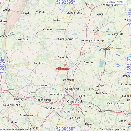
Alfhausen GPS coordinates[2]
52° 30' 0" North, 7° 57' 0" East
| Map corner | latitude | longitude |
|---|---|---|
| Upper-left | 52.92595°, | 7.24688° |
| Center: | 52.5°, | 7.95° |
| Lower-right: | 52.06988°, | 8.65313° |
| Map W x H: | 95.2×95.2 km | = 59.2×59.2mi |
| max Lat: | 55.01917° ⇑22.6% North |
| Alfhausen: | 52.5° |
| min Lat: | ⇓77.4% South 47.40724° |
| min Long | Alfhausen | max Long |
| 5.92978° | 7.95° | 14.98853° |
| W 21.9%⇐ | ⇒78.1% E |
Elevation
Elevation of Alfhausen is 43 m = 141 ft, and this is 206.1 m = 676 ft below average elevation for this country.
| Max E: |
1256 m = 4121 ft | 81.4% |
| Avg. | 249.1 m = 817 ft | |
| Alfhausen | 43 m = 141 ft | |
Min E: |
-5 m = -16 ft | 18.6% |
See also: Germany elevation on elevation.city.
Geographical zone
Alfhausen is located in North temperate zone (between Tropic of Cancer and the Arctic Circle). Distance of this North polar circle is 1563.7 km =971.6 mi to North.| Distance of | km | miles | from Alfhausen |
|---|---|---|---|
| North Pole | 4169.6 | 2590.9 | to North |
| Arctic Circle | 1563.7 | 971.6 | to North |
| Tropic Cancer | 3231.5 | 2008 | to South |
| Equator | 5837.5 | 3627.3 | to South |


Nearby cities:
15 places around Alfhausen: (largest is in red/bold)
• Ankum
7.2 km =4.5 mi,  320°
320°
• Badbergen
15 km =9.3 mi,  8°
8°
• Bersenbrück
5.7 km =3.5 mi,  358°
358°
• Bramsche
10.3 km =6.4 mi,  171°
171°
• Eggermühlen
11.7 km =7.3 mi,  309°
309°
• Gehrde
9.3 km =5.8 mi,  22°
22°
• Holdorf
14.6 km =9.1 mi,  50°
50°
• Kettenkamp
12.2 km =7.6 mi, 319°
• Merzen
8.1 km =5 mi,  256°
256°
• Neuenkirchen
7.8 km =4.8 mi,  81°
81°
• Neuenkirchen
11.9 km =7.4 mi,  219°
219°
• Nortrup
14.1 km =8.8 mi,  334°
334°
• Rieste
4.9 km =3 mi,  112°
112°
• Rüsfort
10.9 km =6.8 mi, 16°
• Voltlage
15.4 km =9.6 mi,  241°
241°
Sources, notices
• [Note1] Compared only with cities in Germany existing in our database
• [Src1] Map data: © OpenStreetMap contributors (CC-BY-SA)
• [Src2] Other city data from geonames.org with taken over terms of usage.
• [Src3] Geographical zone / Annual Mean Temperature by Robert A. Rohde @ Wikipedia
