Ankum geodata
Ankum (Lower Saxony) is a seat of a fourth-order administrative division; located in Germany in Europe/Berlin (GMT+2) time zone. With population of 7,186 people, there are 2148 cities with bigger population in this country. Compared to other cities in Germany, 78% of cities are located further ↓South; 79.4% of cities are located further →East and 76.4% of cities have higher elevation than Ankum. Note1


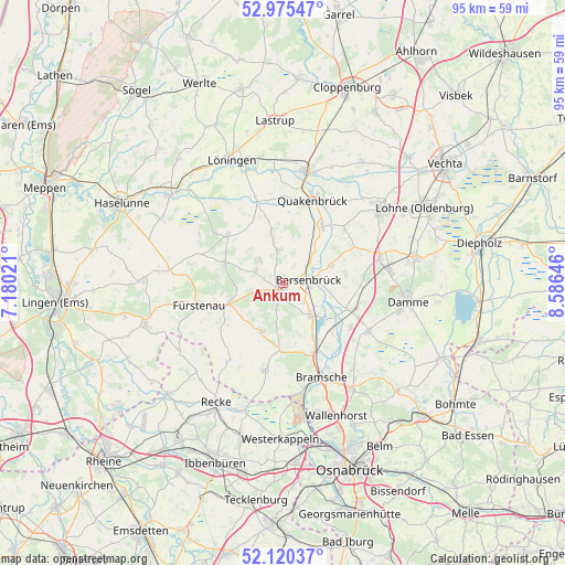
Ankum GPS coordinates[2]
52° 33' 0" North, 7° 52' 59.988" East
| Map corner | latitude | longitude |
|---|---|---|
| Upper-left | 52.97547°, | 7.18021° |
| Center: | 52.55°, | 7.88333° |
| Lower-right: | 52.12037°, | 8.58646° |
| Map W x H: | 95.1×95.1 km | = 59.1×59.1mi |
| max Lat: | 55.01917° ⇑22% North |
| Ankum: | 52.55° |
| min Lat: | ⇓78% South 47.40724° |
| min Long | Ankum | max Long |
| 5.92978° | 7.88333° | 14.98853° |
| W 20.6%⇐ | ⇒79.4% E |
Elevation
Elevation of Ankum is 58 m = 190 ft, and this is 191.1 m = 627 ft below average elevation for this country.
| Max E: |
1256 m = 4121 ft | 76.4% |
| Avg. | 249.1 m = 817 ft | |
| Ankum | 58 m = 190 ft | |
Min E: |
-5 m = -16 ft | 23.6% |
See also: Germany elevation on elevation.city.
Geographical zone
Ankum is located in North temperate zone (between Tropic of Cancer and the Arctic Circle). Distance of this North polar circle is 1558.2 km =968.2 mi to North.| Distance of | km | miles | from Ankum |
|---|---|---|---|
| North Pole | 4164 | 2587.4 | to North |
| Arctic Circle | 1558.2 | 968.2 | to North |
| Tropic Cancer | 3237.1 | 2011.4 | to South |
| Equator | 5843 | 3630.7 | to South |


Nearby cities:
15 places around Ankum: (largest is in red/bold)
• Alfhausen
7.2 km =4.5 mi,  140°
140°
• Badbergen
11.5 km =7.1 mi,  36°
36°
• Berge
12.4 km =7.7 mi,  311°
311°
• Bersenbrück
4.4 km =2.7 mi,  87°
87°
• Bippen
10.8 km =6.7 mi,  290°
290°
• Eggermühlen
4.9 km =3 mi, 292°
• Fürstenau
14.5 km =9 mi,  255°
255°
• Gehrde
8.6 km =5.3 mi,  69°
69°
• Kettenkamp
5 km =3.1 mi,  317°
317°
• Merzen
8.1 km =5 mi,  204°
204°
• Neuenkirchen
13 km =8.1 mi,  109°
109°
• Nortrup
7.4 km =4.6 mi,  348°
348°
• Quakenbrück
14.6 km =9.1 mi,  17°
17°
• Rieste
11.7 km =7.3 mi,  129°
129°
• Rüsfort
9 km =5.6 mi,  57°
57°
Sources, notices
• [Note1] Compared only with cities in Germany existing in our database
• [Src1] Map data: © OpenStreetMap contributors (CC-BY-SA)
• [Src2] Other city data from geonames.org with taken over terms of usage.
• [Src3] Geographical zone / Annual Mean Temperature by Robert A. Rohde @ Wikipedia
