Bramsche geodata
Bramsche (Lower Saxony) is a populated place; located in Germany in Europe/Berlin (GMT+2) time zone. With population of 31,394 people, there are 441 cities with bigger population in this country. Compared to other cities in Germany, 76.3% of cities are located further ↓South; 77.6% of cities are located further →East and 75.3% of cities have higher elevation than Bramsche. Note1


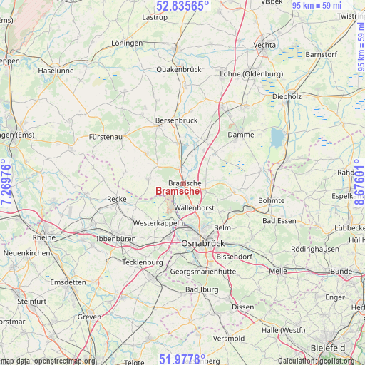
Bramsche GPS coordinates[2]
52° 24' 31.716" North, 7° 58' 22.368" East
| Map corner | latitude | longitude |
|---|---|---|
| Upper-left | 52.83565°, | 7.26976° |
| Center: | 52.40881°, | 7.97288° |
| Lower-right: | 51.9778°, | 8.67601° |
| Map W x H: | 95.4×95.4 km | = 59.3×59.3mi |
| max Lat: | 55.01917° ⇑23.7% North |
| Bramsche: | 52.40881° |
| min Lat: | ⇓76.3% South 47.40724° |
| min Long | Bramsche | max Long |
| 5.92978° | 7.97288° | 14.98853° |
| W 22.4%⇐ | ⇒77.6% E |
Elevation
Elevation of Bramsche is 62 m = 203 ft, and this is 187.1 m = 614 ft below average elevation for this country.
| Max E: |
1256 m = 4121 ft | 75.3% |
| Avg. | 249.1 m = 817 ft | |
| Bramsche | 62 m = 203 ft | |
Min E: |
-5 m = -16 ft | 24.7% |
See also: Germany elevation on elevation.city.
Geographical zone
Bramsche is located in North temperate zone (between Tropic of Cancer and the Arctic Circle). Distance of this North polar circle is 1573.9 km =978 mi to North.| Distance of | km | miles | from Bramsche |
|---|---|---|---|
| North Pole | 4179.7 | 2597.1 | to North |
| Arctic Circle | 1573.9 | 978 | to North |
| Tropic Cancer | 3221.4 | 2001.7 | to South |
| Equator | 5827.3 | 3620.9 | to South |


Nearby cities:
15 places around Bramsche: (largest is in red/bold)
• Alfhausen
10.3 km =6.4 mi,  351°
351°
• Ankum
16.8 km =10.4 mi,  338°
338°
• Belm
16.3 km =10.1 mi,  137°
137°
• Bersenbrück
16 km =9.9 mi, 354°
• Lotte
14.5 km =9 mi,  195°
195°
• Merzen
12.6 km =7.8 mi,  311°
311°
• Mettingen
16.5 km =10.3 mi,  231°
231°
• Neuenkirchen
9.1 km =5.7 mi,  275°
275°
• Neuenkirchen
12.9 km =8 mi,  28°
28°
• Osnabrück
16 km =9.9 mi,  160°
160°
• Recke
17.6 km =10.9 mi,  255°
255°
• Rieste
8.8 km =5.5 mi,  19°
19°
• Voltlage
15.4 km =9.6 mi, 280°
• Wallenhorst
7.2 km =4.5 mi, 155°
• Westerkappeln
11.9 km =7.4 mi,  210°
210°
Sources, notices
• [Note1] Compared only with cities in Germany existing in our database
• [Src1] Map data: © OpenStreetMap contributors (CC-BY-SA)
• [Src2] Other city data from geonames.org with taken over terms of usage.
• [Src3] Geographical zone / Annual Mean Temperature by Robert A. Rohde @ Wikipedia
