Nortrup geodata
Nortrup (Lower Saxony) is a seat of a fourth-order administrative division; located in Germany in Europe/Berlin (GMT+2) time zone. With population of 2,972 people, there are 4025 cities with bigger population in this country. Compared to other cities in Germany, 78.9% of cities are located further ↓South; 79.8% of cities are located further →East and 87% of cities have higher elevation than Nortrup. Note1


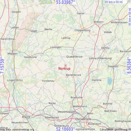
Nortrup GPS coordinates[2]
52° 36' 54.108" North, 7° 51' 38.592" East
| Map corner | latitude | longitude |
|---|---|---|
| Upper-left | 53.03987°, | 7.15759° |
| Center: | 52.61503°, | 7.86072° |
| Lower-right: | 52.18603°, | 8.56384° |
| Map W x H: | 94.9×94.9 km | = 59×59mi |
| max Lat: | 55.01917° ⇑21.1% North |
| Nortrup: | 52.61503° |
| min Lat: | ⇓78.9% South 47.40724° |
| min Long | Nortrup | max Long |
| 5.92978° | 7.86072° | 14.98853° |
| W 20.2%⇐ | ⇒79.8% E |
Elevation
Elevation of Nortrup is 30 m = 98 ft, and this is 219.1 m = 719 ft below average elevation for this country.
| Max E: |
1256 m = 4121 ft | 87% |
| Avg. | 249.1 m = 817 ft | |
| Nortrup | 30 m = 98 ft | |
Min E: |
-5 m = -16 ft | 13% |
See also: Germany elevation on elevation.city.
Geographical zone
Nortrup is located in North temperate zone (between Tropic of Cancer and the Arctic Circle). Distance of this North polar circle is 1550.9 km =963.7 mi to North.| Distance of | km | miles | from Nortrup |
|---|---|---|---|
| North Pole | 4156.8 | 2582.9 | to North |
| Arctic Circle | 1550.9 | 963.7 | to North |
| Tropic Cancer | 3244.3 | 2015.9 | to South |
| Equator | 5850.2 | 3635.1 | to South |


Nearby cities:
15 places around Nortrup: (largest is in red/bold)
• Alfhausen
14.1 km =8.8 mi,  154°
154°
• Ankum
7.4 km =4.6 mi,  168°
168°
• Badbergen
8.5 km =5.3 mi,  76°
76°
• Berge
7.8 km =4.8 mi,  276°
276°
• Bersenbrück
9.2 km =5.7 mi,  139°
139°
• Bippen
9.3 km =5.8 mi,  247°
247°
• Eggermühlen
6.1 km =3.8 mi,  208°
208°
• Essen
13 km =8.1 mi,  23°
23°
• Gehrde
10.5 km =6.5 mi,  113°
113°
• Kettenkamp
4 km =2.5 mi, 207°
• Löningen
15.2 km =9.4 mi,  332°
332°
• Menslage
8.2 km =5.1 mi,  338°
338°
• Merzen
14.8 km =9.2 mi,  187°
187°
• Quakenbrück
9 km =5.6 mi,  42°
42°
• Rüsfort
9.5 km =5.9 mi,  104°
104°
Sources, notices
• [Note1] Compared only with cities in Germany existing in our database
• [Src1] Map data: © OpenStreetMap contributors (CC-BY-SA)
• [Src2] Other city data from geonames.org with taken over terms of usage.
• [Src3] Geographical zone / Annual Mean Temperature by Robert A. Rohde @ Wikipedia
