Kettenkamp geodata
Kettenkamp (Lower Saxony) is a seat of a fourth-order administrative division; located in Germany in Europe/Berlin (GMT+2) time zone. With population of 1,760 people, there are 5412 cities with bigger population in this country. Compared to other cities in Germany, 78.5% of cities are located further ↓South; 80.4% of cities are located further →East and 79.9% of cities have higher elevation than Kettenkamp. Note1


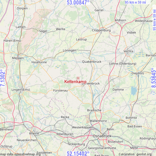
Kettenkamp GPS coordinates[2]
52° 34' 59.988" North, 7° 49' 59.988" East
| Map corner | latitude | longitude |
|---|---|---|
| Upper-left | 53.00847°, | 7.1302° |
| Center: | 52.58333°, | 7.83333° |
| Lower-right: | 52.15402°, | 8.53645° |
| Map W x H: | 95×95 km | = 59×59mi |
| max Lat: | 55.01917° ⇑21.5% North |
| Kettenkamp: | 52.58333° |
| min Lat: | ⇓78.5% South 47.40724° |
| min Long | Kettenkamp | max Long |
| 5.92978° | 7.83333° | 14.98853° |
| W 19.6%⇐ | ⇒80.4% E |
Elevation
Elevation of Kettenkamp is 47 m = 154 ft, and this is 202.1 m = 663 ft below average elevation for this country.
| Max E: |
1256 m = 4121 ft | 79.9% |
| Avg. | 249.1 m = 817 ft | |
| Kettenkamp | 47 m = 154 ft | |
Min E: |
-5 m = -16 ft | 20.1% |
See also: Germany elevation on elevation.city.
Geographical zone
Kettenkamp is located in North temperate zone (between Tropic of Cancer and the Arctic Circle). Distance of this North polar circle is 1554.5 km =965.9 mi to North.| Distance of | km | miles | from Kettenkamp |
|---|---|---|---|
| North Pole | 4160.3 | 2585.1 | to North |
| Arctic Circle | 1554.5 | 965.9 | to North |
| Tropic Cancer | 3240.8 | 2013.7 | to South |
| Equator | 5846.7 | 3633 | to South |


Nearby cities:
15 places around Kettenkamp: (largest is in red/bold)
• Alfhausen
12.2 km =7.6 mi,  139°
139°
• Ankum
5 km =3.1 mi, 137°
• Badbergen
11.6 km =7.2 mi,  61°
61°
• Berge
7.4 km =4.6 mi,  306°
306°
• Bersenbrück
8.5 km =5.3 mi,  114°
114°
• Bippen
6.8 km =4.2 mi,  270°
270°
• Eggermühlen
2.2 km =1.4 mi,  211°
211°
• Fürstenau
12.9 km =8 mi,  235°
235°
• Gehrde
11.5 km =7.1 mi,  93°
93°
• Menslage
11.2 km =7 mi,  354°
354°
• Merzen
11.1 km =6.9 mi,  180°
180°
• Nortrup
4 km =2.5 mi,  27°
27°
• Quakenbrück
12.9 km =8 mi,  37°
37°
• Rüsfort
11.1 km =6.9 mi,  84°
84°
• Wettrup
15.8 km =9.8 mi, 272°
Sources, notices
• [Note1] Compared only with cities in Germany existing in our database
• [Src1] Map data: © OpenStreetMap contributors (CC-BY-SA)
• [Src2] Other city data from geonames.org with taken over terms of usage.
• [Src3] Geographical zone / Annual Mean Temperature by Robert A. Rohde @ Wikipedia
