Aidlingen geodata
Aidlingen (Baden-Württemberg) is a seat of a fourth-order administrative division; located in Germany in Europe/Berlin (GMT+2) time zone. With population of 9,285 people, there are 1742 cities with bigger population in this country. Compared to other cities in Germany, 86.8% of cities are located further ↑North; 66.7% of cities are located further →East and 79.1% of cities have lower elevation than Aidlingen. Note1
Administrative division(s):
- Level 1: Baden-Württemberg
- Level 2: Regierungsbezirk Stuttgart
- Level 3: Landkreis Böblingen
- Level 4: Aidlingen


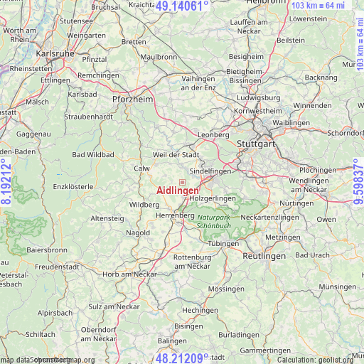
Aidlingen GPS coordinates[2]
48° 40' 42.564" North, 8° 53' 42.864" East
| Map corner | latitude | longitude |
|---|---|---|
| Upper-left | 49.14061°, | 8.19212° |
| Center: | 48.67849°, | 8.89524° |
| Lower-right: | 48.21209°, | 9.59837° |
| Map W x H: | 103.2×103.2 km | = 64.1×64.1mi |
| max Lat: | 55.01917° ⇑86.8% North |
| Aidlingen: | 48.67849° |
| min Lat: | ⇓13.2% South 47.40724° |
| min Long | Aidlingen | max Long |
| 5.92978° | 8.89524° | 14.98853° |
| W 33.3%⇐ | ⇒66.7% E |
Elevation
Elevation of Aidlingen is 428 m = 1404 ft, and this is 178.9 m = 587 ft above average elevation for this country.
| Max E: |
1256 m = 4121 ft | 20.9% |
| Aidlingen | 428 m 1404 ft | |
| Avg. | 249.1 m = 817 ft | |
Min E: |
-5 m = -16 ft | 79.1% |
See also: Germany elevation on elevation.city.
Geographical zone
Aidlingen is located in North temperate zone (between Tropic of Cancer and the Arctic Circle). Distance of this North polar circle is 1988.6 km =1235.7 mi to North.| Distance of | km | miles | from Aidlingen |
|---|---|---|---|
| North Pole | 4594.5 | 2854.9 | to North |
| Arctic Circle | 1988.6 | 1235.7 | to North |
| Tropic Cancer | 2806.6 | 1743.9 | to South |
| Equator | 5412.5 | 3363.2 | to South |


Nearby cities:
15 places around Aidlingen: (largest is in red/bold)
• Altdorf
9.1 km =5.7 mi,  125°
125°
• Althengstett
8.9 km =5.5 mi,  303°
303°
• Böblingen
8.6 km =5.3 mi,  87°
87°
• Deckenpfronn
6 km =3.7 mi,  239°
239°
• Ehningen
4 km =2.5 mi,  122°
122°
• Gechingen
5.2 km =3.2 mi,  291°
291°
• Grafenau
4.2 km =2.6 mi,  17°
17°
• Gärtringen
4.1 km =2.5 mi,  174°
174°
• Herrenberg
9.5 km =5.9 mi,  192°
192°
• Hildrizhausen
8 km =5 mi,  139°
139°
• Magstadt
9 km =5.6 mi,  35°
35°
• Nufringen
6.2 km =3.9 mi,  183°
183°
• Ostelsheim
6.3 km =3.9 mi,  326°
326°
• Sindelfingen
9.2 km =5.7 mi,  74°
74°
• Weil der Stadt
8.1 km =5 mi,  347°
347°
Sources, notices
• [Note1] Compared only with cities in Germany existing in our database
• [Src1] Map data: © OpenStreetMap contributors (CC-BY-SA)
• [Src2] Other city data from geonames.org with taken over terms of usage.
• [Src3] Geographical zone / Annual Mean Temperature by Robert A. Rohde @ Wikipedia
