Althengstett geodata
Althengstett (Baden-Württemberg) is a seat of a fourth-order administrative division; located in Germany in Europe/Berlin (GMT+2) time zone. With population of 8,201 people, there are 1927 cities with bigger population in this country. Compared to other cities in Germany, 86.2% of cities are located further ↑North; 68% of cities are located further →East and 89.3% of cities have lower elevation than Althengstett. Note1
Administrative division(s):
- Level 1: Baden-Württemberg
- Level 2: Karlsruhe Region
- Level 3: Landkreis Calw
- Level 4: Althengstett


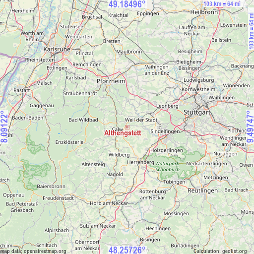
Althengstett GPS coordinates[2]
48° 43' 23.7" North, 8° 47' 39.624" East
| Map corner | latitude | longitude |
|---|---|---|
| Upper-left | 49.18496°, | 8.09122° |
| Center: | 48.72325°, | 8.79434° |
| Lower-right: | 48.25726°, | 9.49747° |
| Map W x H: | 103.2×103.1 km | = 64.1×64.1mi |
| max Lat: | 55.01917° ⇑86.2% North |
| Althengstett: | 48.72325° |
| min Lat: | ⇓13.8% South 47.40724° |
| min Long | Althengstett | max Long |
| 5.92978° | 8.79434° | 14.98853° |
| W 32%⇐ | ⇒68% E |
Elevation
Elevation of Althengstett is 506 m = 1660 ft, and this is 256.9 m = 843 ft above average elevation for this country.
| Max E: |
1256 m = 4121 ft | 10.7% |
| Althengstett | 506 m 1660 ft | |
| Avg. | 249.1 m = 817 ft | |
Min E: |
-5 m = -16 ft | 89.3% |
See also: Germany elevation on elevation.city.
Geographical zone
Althengstett is located in North temperate zone (between Tropic of Cancer and the Arctic Circle). Distance of this North polar circle is 1983.7 km =1232.6 mi to North.| Distance of | km | miles | from Althengstett |
|---|---|---|---|
| North Pole | 4589.5 | 2851.8 | to North |
| Arctic Circle | 1983.7 | 1232.6 | to North |
| Tropic Cancer | 2811.6 | 1747 | to South |
| Equator | 5417.5 | 3366.3 | to South |


Nearby cities:
15 places around Althengstett: (largest is in red/bold)
• Aidlingen
8.9 km =5.5 mi,  123°
123°
• Bad Liebenzell
7.4 km =4.6 mi,  320°
320°
• Bad Teinach-Zavelstein
8.3 km =5.2 mi,  243°
243°
• Calw
4.1 km =2.5 mi,  255°
255°
• Deckenpfronn
8.3 km =5.2 mi,  164°
164°
• Gechingen
4 km =2.5 mi,  140°
140°
• Grafenau
8.7 km =5.4 mi,  96°
96°
• Heimsheim
10.7 km =6.6 mi,  30°
30°
• Holzbronn
8 km =5 mi,  207°
207°
• Neubulach
10 km =6.2 mi,  226°
226°
• Neuhausen
7.8 km =4.8 mi,  350°
350°
• Oberreichenbach
9.4 km =5.8 mi,  276°
276°
• Ostelsheim
4 km =2.5 mi,  85°
85°
• Simmozheim
3.4 km =2.1 mi,  21°
21°
• Weil der Stadt
6.4 km =4 mi,  62°
62°
Sources, notices
• [Note1] Compared only with cities in Germany existing in our database
• [Src1] Map data: © OpenStreetMap contributors (CC-BY-SA)
• [Src2] Other city data from geonames.org with taken over terms of usage.
• [Src3] Geographical zone / Annual Mean Temperature by Robert A. Rohde @ Wikipedia
