Altdorf geodata
Altdorf (Baden-Württemberg) is a seat of a fourth-order administrative division; located in Germany in Europe/Berlin (GMT+2) time zone. With population of 4,426 people, there are 3080 cities with bigger population in this country. Compared to other cities in Germany, 87.4% of cities are located further ↑North; 65.5% of cities are located further →East and 86.2% of cities have lower elevation than Altdorf. Note1
Administrative division(s):
- Level 1: Baden-Württemberg
- Level 2: Regierungsbezirk Stuttgart
- Level 3: Landkreis Böblingen
- Level 4: Altdorf


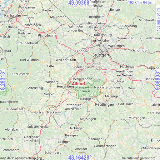
Altdorf GPS coordinates[2]
48° 37' 52.032" North, 8° 59' 46.536" East
| Map corner | latitude | longitude |
|---|---|---|
| Upper-left | 49.09368°, | 8.29313° |
| Center: | 48.63112°, | 8.99626° |
| Lower-right: | 48.16428°, | 9.69938° |
| Map W x H: | 103.3×103.3 km | = 64.2×64.2mi |
| max Lat: | 55.01917° ⇑87.4% North |
| Altdorf: | 48.63112° |
| min Lat: | ⇓12.6% South 47.40724° |
| min Long | Altdorf | max Long |
| 5.92978° | 8.99626° | 14.98853° |
| W 34.5%⇐ | ⇒65.5% E |
Elevation
Elevation of Altdorf is 479 m = 1572 ft, and this is 229.9 m = 754 ft above average elevation for this country.
| Max E: |
1256 m = 4121 ft | 13.8% |
| Altdorf | 479 m 1572 ft | |
| Avg. | 249.1 m = 817 ft | |
Min E: |
-5 m = -16 ft | 86.2% |
See also: Germany elevation on elevation.city.
Geographical zone
Altdorf is located in North temperate zone (between Tropic of Cancer and the Arctic Circle). Distance of this North polar circle is 1993.9 km =1239 mi to North.| Distance of | km | miles | from Altdorf |
|---|---|---|---|
| North Pole | 4599.8 | 2858.2 | to North |
| Arctic Circle | 1993.9 | 1239 | to North |
| Tropic Cancer | 2801.4 | 1740.7 | to South |
| Equator | 5407.3 | 3359.9 | to South |


Nearby cities:
15 places around Altdorf: (largest is in red/bold)
• Aidlingen
9.1 km =5.7 mi,  305°
305°
• Böblingen
5.8 km =3.6 mi,  11°
11°
• Dettenhausen
8.1 km =5 mi,  108°
108°
• Ehningen
5.1 km =3.2 mi, 307°
• Grafenau
11.1 km =6.9 mi,  326°
326°
• Gärtringen
7.1 km =4.4 mi,  279°
279°
• Herrenberg
10.3 km =6.4 mi,  247°
247°
• Hildrizhausen
2.3 km =1.4 mi, 250°
• Holzgerlingen
1.5 km =0.9 mi,  49°
49°
• Nufringen
7.9 km =4.9 mi,  263°
263°
• Schönaich
5.6 km =3.5 mi,  56°
56°
• Sindelfingen
7.8 km =4.8 mi, 11°
• Steinenbronn
9.7 km =6 mi,  65°
65°
• Waldenbuch
10 km =6.2 mi,  85°
85°
• Weil im Schönbuch
5 km =3.1 mi,  100°
100°
Sources, notices
• [Note1] Compared only with cities in Germany existing in our database
• [Src1] Map data: © OpenStreetMap contributors (CC-BY-SA)
• [Src2] Other city data from geonames.org with taken over terms of usage.
• [Src3] Geographical zone / Annual Mean Temperature by Robert A. Rohde @ Wikipedia
