Ostelsheim geodata
Ostelsheim (Baden-Württemberg) is a seat of a fourth-order administrative division; located in Germany in Europe/Berlin (GMT+2) time zone. With population of 2,541 people, there are 4390 cities with bigger population in this country. Compared to other cities in Germany, 86.1% of cities are located further ↑North; 67.3% of cities are located further →East and 83.8% of cities have lower elevation than Ostelsheim. Note1
Administrative division(s):
- Level 1: Baden-Württemberg
- Level 2: Karlsruhe Region
- Level 3: Landkreis Calw
- Level 4: Ostelsheim


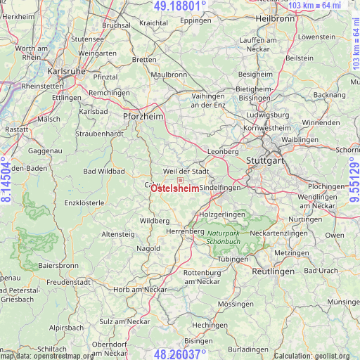
Ostelsheim GPS coordinates[2]
48° 43' 34.788" North, 8° 50' 53.376" East
| Map corner | latitude | longitude |
|---|---|---|
| Upper-left | 49.18801°, | 8.14504° |
| Center: | 48.72633°, | 8.84816° |
| Lower-right: | 48.26037°, | 9.55129° |
| Map W x H: | 103.1×103.1 km | = 64.1×64.1mi |
| max Lat: | 55.01917° ⇑86.1% North |
| Ostelsheim: | 48.72633° |
| min Lat: | ⇓13.9% South 47.40724° |
| min Long | Ostelsheim | max Long |
| 5.92978° | 8.84816° | 14.98853° |
| W 32.7%⇐ | ⇒67.3% E |
Elevation
Elevation of Ostelsheim is 460 m = 1509 ft, and this is 210.9 m = 692 ft above average elevation for this country.
| Max E: |
1256 m = 4121 ft | 16.2% |
| Ostelsheim | 460 m 1509 ft | |
| Avg. | 249.1 m = 817 ft | |
Min E: |
-5 m = -16 ft | 83.8% |
See also: Germany elevation on elevation.city.
Geographical zone
Ostelsheim is located in North temperate zone (between Tropic of Cancer and the Arctic Circle). Distance of this North polar circle is 1983.3 km =1232.4 mi to North.| Distance of | km | miles | from Ostelsheim |
|---|---|---|---|
| North Pole | 4589.2 | 2851.6 | to North |
| Arctic Circle | 1983.3 | 1232.4 | to North |
| Tropic Cancer | 2811.9 | 1747.2 | to South |
| Equator | 5417.9 | 3366.5 | to South |


Nearby cities:
15 places around Ostelsheim: (largest is in red/bold)
• Aidlingen
6.3 km =3.9 mi,  146°
146°
• Althengstett
4 km =2.5 mi,  265°
265°
• Bad Liebenzell
10.2 km =6.3 mi,  301°
301°
• Calw
8 km =5 mi,  260°
260°
• Deckenpfronn
8.5 km =5.3 mi,  191°
191°
• Ehningen
10.1 km =6.3 mi,  137°
137°
• Gechingen
3.7 km =2.3 mi,  201°
201°
• Grafenau
4.9 km =3 mi,  105°
105°
• Gärtringen
10.2 km =6.3 mi,  157°
157°
• Heimsheim
9 km =5.6 mi,  9°
9°
• Magstadt
8.9 km =5.5 mi,  76°
76°
• Neuhausen
9 km =5.6 mi,  324°
324°
• Renningen
8.2 km =5.1 mi,  53°
53°
• Simmozheim
3.9 km =2.4 mi, 315°
• Weil der Stadt
3.1 km =1.9 mi,  33°
33°
Sources, notices
• [Note1] Compared only with cities in Germany existing in our database
• [Src1] Map data: © OpenStreetMap contributors (CC-BY-SA)
• [Src2] Other city data from geonames.org with taken over terms of usage.
• [Src3] Geographical zone / Annual Mean Temperature by Robert A. Rohde @ Wikipedia
