Grafenau geodata
Grafenau (Baden-Württemberg) is a seat of a fourth-order administrative division; located in Germany in Europe/Berlin (GMT+2) time zone. With population of 6,425 people, there are 2324 cities with bigger population in this country. Compared to other cities in Germany, 86.3% of cities are located further ↑North; 66.5% of cities are located further →East and 81.4% of cities have lower elevation than Grafenau. Note1
Administrative division(s):
- Level 1: Baden-Württemberg
- Level 2: Regierungsbezirk Stuttgart
- Level 3: Landkreis Böblingen
- Level 4: Grafenau


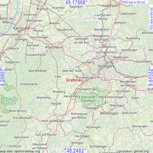
Grafenau GPS coordinates[2]
48° 42' 51.372" North, 8° 54' 43.884" East
| Map corner | latitude | longitude |
|---|---|---|
| Upper-left | 49.17606°, | 8.20907° |
| Center: | 48.71427°, | 8.91219° |
| Lower-right: | 48.2482°, | 9.61532° |
| Map W x H: | 103.2×103.2 km | = 64.1×64.1mi |
| max Lat: | 55.01917° ⇑86.3% North |
| Grafenau: | 48.71427° |
| min Lat: | ⇓13.7% South 47.40724° |
| min Long | Grafenau | max Long |
| 5.92978° | 8.91219° | 14.98853° |
| W 33.5%⇐ | ⇒66.5% E |
Elevation
Elevation of Grafenau is 443 m = 1453 ft, and this is 193.9 m = 636 ft above average elevation for this country.
| Max E: |
1256 m = 4121 ft | 18.6% |
| Grafenau | 443 m 1453 ft | |
| Avg. | 249.1 m = 817 ft | |
Min E: |
-5 m = -16 ft | 81.4% |
See also: Germany elevation on elevation.city.
Geographical zone
Grafenau is located in North temperate zone (between Tropic of Cancer and the Arctic Circle). Distance of this North polar circle is 1984.7 km =1233.2 mi to North.| Distance of | km | miles | from Grafenau |
|---|---|---|---|
| North Pole | 4590.5 | 2852.4 | to North |
| Arctic Circle | 1984.7 | 1233.2 | to North |
| Tropic Cancer | 2810.6 | 1746.4 | to South |
| Equator | 5416.5 | 3365.7 | to South |


Nearby cities:
15 places around Grafenau: (largest is in red/bold)
• Aidlingen
4.2 km =2.6 mi,  197°
197°
• Althengstett
8.7 km =5.4 mi,  276°
276°
• Böblingen
8.1 km =5 mi,  116°
116°
• Deckenpfronn
9.5 km =5.9 mi,  222°
222°
• Ehningen
6.5 km =4 mi,  160°
160°
• Gechingen
6.4 km =4 mi,  250°
250°
• Gärtringen
8.1 km =5 mi,  185°
185°
• Magstadt
5.2 km =3.2 mi,  49°
49°
• Nufringen
10.3 km =6.4 mi, 189°
• Ostelsheim
4.9 km =3 mi,  285°
285°
• Renningen
6.5 km =4 mi,  17°
17°
• Rutesheim
10.7 km =6.6 mi,  13°
13°
• Simmozheim
8.5 km =5.3 mi,  299°
299°
• Sindelfingen
7.8 km =4.8 mi,  101°
101°
• Weil der Stadt
4.9 km =3 mi,  322°
322°
Sources, notices
• [Note1] Compared only with cities in Germany existing in our database
• [Src1] Map data: © OpenStreetMap contributors (CC-BY-SA)
• [Src2] Other city data from geonames.org with taken over terms of usage.
• [Src3] Geographical zone / Annual Mean Temperature by Robert A. Rohde @ Wikipedia
