Ahlerstedt geodata
Ahlerstedt (Lower Saxony) is a seat of a fourth-order administrative division; located in Germany in Europe/Berlin (GMT+2) time zone. With population of 5,063 people, there are 2803 cities with bigger population in this country. Compared to other cities in Germany, 84.5% of cities are located further ↓South; 58.6% of cities are located further →East and 84.9% of cities have higher elevation than Ahlerstedt. Note1


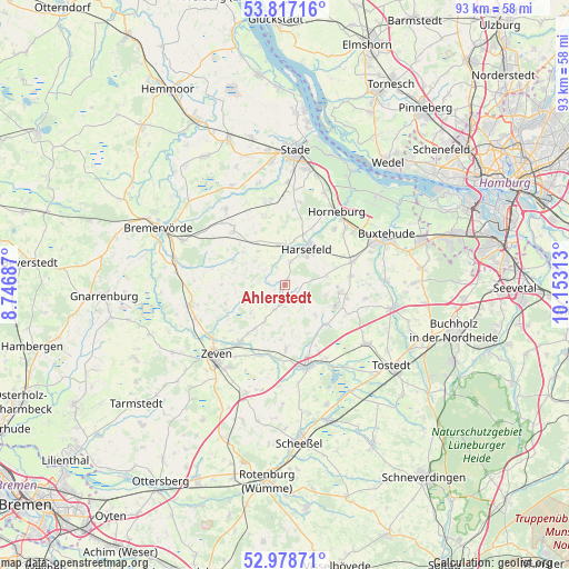
Ahlerstedt GPS coordinates[2]
53° 24' 0" North, 9° 27' 0" East
| Map corner | latitude | longitude |
|---|---|---|
| Upper-left | 53.81716°, | 8.74687° |
| Center: | 53.4°, | 9.45° |
| Lower-right: | 52.97871°, | 10.15313° |
| Map W x H: | 93.2×93.2 km | = 57.9×57.9mi |
| max Lat: | 55.01917° ⇑15.5% North |
| Ahlerstedt: | 53.4° |
| min Lat: | ⇓84.5% South 47.40724° |
| min Long | Ahlerstedt | max Long |
| 5.92978° | 9.45° | 14.98853° |
| W 41.4%⇐ | ⇒58.6% E |
Elevation
Elevation of Ahlerstedt is 35 m = 115 ft, and this is 214.1 m = 702 ft below average elevation for this country.
| Max E: |
1256 m = 4121 ft | 84.9% |
| Avg. | 249.1 m = 817 ft | |
| Ahlerstedt | 35 m = 115 ft | |
Min E: |
-5 m = -16 ft | 15.1% |
See also: Germany elevation on elevation.city.
Geographical zone
Ahlerstedt is located in North temperate zone (between Tropic of Cancer and the Arctic Circle). Distance of this North polar circle is 1463.7 km =909.5 mi to North.| Distance of | km | miles | from Ahlerstedt |
|---|---|---|---|
| North Pole | 4069.5 | 2528.7 | to North |
| Arctic Circle | 1463.7 | 909.5 | to North |
| Tropic Cancer | 3331.6 | 2070.2 | to South |
| Equator | 5937.5 | 3689.4 | to South |


Nearby cities:
15 places around Ahlerstedt: (largest is in red/bold)
• Anderlingen
10.1 km =6.3 mi,  253°
253°
• Apensen
11.7 km =7.3 mi,  71°
71°
• Bargstedt
7.4 km =4.6 mi,  0°
0°
• Beckdorf
11.2 km =7 mi,  80°
80°
• Bliedersdorf
12.1 km =7.5 mi,  39°
39°
• Brest
7.1 km =4.4 mi,  321°
321°
• Farven
9.6 km =6 mi,  292°
292°
• Halvesbostel
11 km =6.8 mi,  116°
116°
• Harsefeld
7 km =4.3 mi,  30°
30°
• Heeslingen
12.1 km =7.5 mi,  219°
219°
• Klein Meckelsen
11.1 km =6.9 mi,  180°
180°
• Lengenbostel
12 km =7.5 mi,  158°
158°
• Sauensiek
10.1 km =6.3 mi,  100°
100°
• Vierden
8.1 km =5 mi, 155°
• Wohnste
7.8 km =4.8 mi,  135°
135°
Sources, notices
• [Note1] Compared only with cities in Germany existing in our database
• [Src1] Map data: © OpenStreetMap contributors (CC-BY-SA)
• [Src2] Other city data from geonames.org with taken over terms of usage.
• [Src3] Geographical zone / Annual Mean Temperature by Robert A. Rohde @ Wikipedia
