Anderlingen geodata
Anderlingen (Lower Saxony) is a seat of a fourth-order administrative division; located in Germany in Europe/Berlin (GMT+2) time zone. With population of 937 people, there are 7398 cities with bigger population in this country. Compared to other cities in Germany, 84.3% of cities are located further ↓South; 60.7% of cities are located further →East and 88% of cities have higher elevation than Anderlingen. Note1


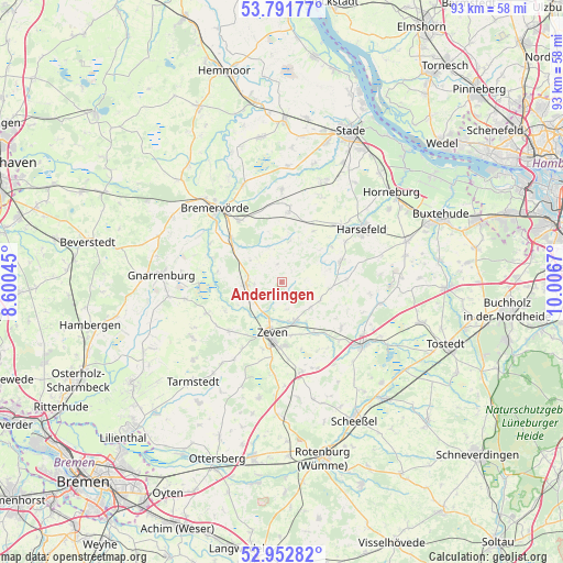
Anderlingen GPS coordinates[2]
53° 22' 27.696" North, 9° 18' 12.852" East
| Map corner | latitude | longitude |
|---|---|---|
| Upper-left | 53.79177°, | 8.60045° |
| Center: | 53.37436°, | 9.30357° |
| Lower-right: | 52.95282°, | 10.0067° |
| Map W x H: | 93.3×93.3 km | = 58×58mi |
| max Lat: | 55.01917° ⇑15.7% North |
| Anderlingen: | 53.37436° |
| min Lat: | ⇓84.3% South 47.40724° |
| min Long | Anderlingen | max Long |
| 5.92978° | 9.30357° | 14.98853° |
| W 39.3%⇐ | ⇒60.7% E |
Elevation
Elevation of Anderlingen is 27 m = 89 ft, and this is 222.1 m = 729 ft below average elevation for this country.
| Max E: |
1256 m = 4121 ft | 88% |
| Avg. | 249.1 m = 817 ft | |
| Anderlingen | 27 m = 89 ft | |
Min E: |
-5 m = -16 ft | 12% |
See also: Germany elevation on elevation.city.
Geographical zone
Anderlingen is located in North temperate zone (between Tropic of Cancer and the Arctic Circle). Distance of this North polar circle is 1466.5 km =911.2 mi to North.| Distance of | km | miles | from Anderlingen |
|---|---|---|---|
| North Pole | 4072.4 | 2530.5 | to North |
| Arctic Circle | 1466.5 | 911.2 | to North |
| Tropic Cancer | 3328.8 | 2068.4 | to South |
| Equator | 5934.7 | 3687.7 | to South |


Nearby cities:
15 places around Anderlingen: (largest is in red/bold)
• Ahlerstedt
10.1 km =6.3 mi,  73°
73°
• Brest
9.9 km =6.2 mi,  32°
32°
• Deinstedt
6.6 km =4.1 mi,  315°
315°
• Farven
6.6 km =4.1 mi,  7°
7°
• Groß Meckelsen
14 km =8.7 mi,  136°
136°
• Heeslingen
6.7 km =4.2 mi,  162°
162°
• Klein Meckelsen
12.8 km =8 mi,  130°
130°
• Kutenholz
12 km =7.5 mi, 5°
• Ostereistedt
12.3 km =7.6 mi,  227°
227°
• Rhade
13.6 km =8.5 mi,  248°
248°
• Sandbostel
12.2 km =7.6 mi,  288°
288°
• Seedorf
5.4 km =3.4 mi,  239°
239°
• Selsingen
6 km =3.7 mi,  268°
268°
• Vierden
13.8 km =8.6 mi,  109°
109°
• Zeven
8.8 km =5.5 mi,  191°
191°
Sources, notices
• [Note1] Compared only with cities in Germany existing in our database
• [Src1] Map data: © OpenStreetMap contributors (CC-BY-SA)
• [Src2] Other city data from geonames.org with taken over terms of usage.
• [Src3] Geographical zone / Annual Mean Temperature by Robert A. Rohde @ Wikipedia
