Aham geodata
Aham (Bavaria) is a populated place; located in Germany in Europe/Berlin (GMT+2) time zone. With population of 1,957 people, there are 5122 cities with bigger population in this country. Compared to other cities in Germany, 90.8% of cities are located further ↑North; 84% of cities are located further ←West and 84.5% of cities have lower elevation than Aham. Note1
Administrative division(s):
- Level 1: Bavaria
- Level 2: Upper Bavaria
- Level 3: Landkreis Erding
- Level 4: Taufkirchen (Vils)


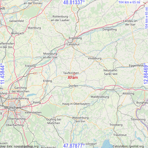
Aham GPS coordinates[2]
48° 20' 53.556" North, 12° 9' 41.616" East
| Map corner | latitude | longitude |
|---|---|---|
| Upper-left | 48.81337°, | 11.45844° |
| Center: | 48.34821°, | 12.16156° |
| Lower-right: | 47.87877°, | 12.86469° |
| Map W x H: | 103.9×103.9 km | = 64.6×64.6mi |
| max Lat: | 55.01917° ⇑90.8% North |
| Aham: | 48.34821° |
| min Lat: | ⇓9.2% South 47.40724° |
| min Long | Aham | max Long |
| 5.92978° | 12.16156° | 14.98853° |
| W 84%⇐ | ⇒16% E |
Elevation
Elevation of Aham is 465 m = 1526 ft, and this is 215.9 m = 708 ft above average elevation for this country.
| Max E: |
1256 m = 4121 ft | 15.5% |
| Aham | 465 m 1526 ft | |
| Avg. | 249.1 m = 817 ft | |
Min E: |
-5 m = -16 ft | 84.5% |
See also: Germany elevation on elevation.city.
Geographical zone
Aham is located in North temperate zone (between Tropic of Cancer and the Arctic Circle). Distance of this North polar circle is 2025.4 km =1258.5 mi to North.| Distance of | km | miles | from Aham |
|---|---|---|---|
| North Pole | 4631.2 | 2877.7 | to North |
| Arctic Circle | 2025.4 | 1258.5 | to North |
| Tropic Cancer | 2769.9 | 1721.1 | to South |
| Equator | 5375.8 | 3340.4 | to South |


Nearby cities:
15 places around Aham: (largest is in red/bold)
• Altfraunhofen
11.3 km =7 mi,  1°
1°
• Baierbach
8.1 km =5 mi,  20°
20°
• Buchbach
9.2 km =5.7 mi,  115°
115°
• Dorfen
8.7 km =5.4 mi,  180°
180°
• Fraunberg
12.1 km =7.5 mi,  279°
279°
• Hohenpolding
4.4 km =2.7 mi,  331°
331°
• Inning am Holz
6.4 km =4 mi,  268°
268°
• Kirchberg
10.1 km =6.3 mi,  304°
304°
• Neufraunhofen
7.1 km =4.4 mi,  35°
35°
• Schwindegg
11.2 km =7 mi,  139°
139°
• Steinkirchen
7 km =4.3 mi, 304°
• Taufkirchen
2.2 km =1.4 mi, 274°
• Velden
7.3 km =4.5 mi,  73°
73°
• Vilsheim
11.9 km =7.4 mi,  340°
340°
• Wurmsham
12.7 km =7.9 mi,  89°
89°
Sources, notices
• [Note1] Compared only with cities in Germany existing in our database
• [Src1] Map data: © OpenStreetMap contributors (CC-BY-SA)
• [Src2] Other city data from geonames.org with taken over terms of usage.
• [Src3] Geographical zone / Annual Mean Temperature by Robert A. Rohde @ Wikipedia
