Steinkirchen geodata
Steinkirchen (Bavaria) is a seat of a fourth-order administrative division; located in Germany in Europe/Berlin (GMT+2) time zone. With population of 1,185 people, there are 6604 cities with bigger population in this country. Compared to other cities in Germany, 90.4% of cities are located further ↑North; 82.9% of cities are located further ←West and 89% of cities have lower elevation than Steinkirchen. Note1
Administrative division(s):
- Level 1: Bavaria
- Level 2: Upper Bavaria
- Level 3: Landkreis Erding
- Level 4: Steinkirchen


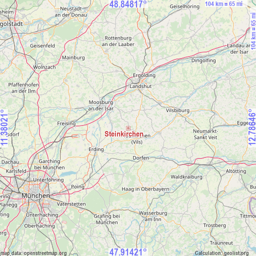
Steinkirchen GPS coordinates[2]
48° 22' 59.988" North, 12° 4' 59.988" East
| Map corner | latitude | longitude |
|---|---|---|
| Upper-left | 48.84817°, | 11.38021° |
| Center: | 48.38333°, | 12.08333° |
| Lower-right: | 47.91421°, | 12.78646° |
| Map W x H: | 103.8×103.8 km | = 64.5×64.5mi |
| max Lat: | 55.01917° ⇑90.4% North |
| Steinkirchen: | 48.38333° |
| min Lat: | ⇓9.6% South 47.40724° |
| min Long | Steinkirchen | max Long |
| 5.92978° | 12.08333° | 14.98853° |
| W 82.9%⇐ | ⇒17.1% E |
Elevation
Elevation of Steinkirchen is 504 m = 1654 ft, and this is 254.9 m = 836 ft above average elevation for this country.
| Max E: |
1256 m = 4121 ft | 11% |
| Steinkirchen | 504 m 1654 ft | |
| Avg. | 249.1 m = 817 ft | |
Min E: |
-5 m = -16 ft | 89% |
See also: Germany elevation on elevation.city.
Geographical zone
Steinkirchen is located in North temperate zone (between Tropic of Cancer and the Arctic Circle). Distance of this North polar circle is 2021.5 km =1256.1 mi to North.| Distance of | km | miles | from Steinkirchen |
|---|---|---|---|
| North Pole | 4627.3 | 2875.3 | to North |
| Arctic Circle | 2021.5 | 1256.1 | to North |
| Tropic Cancer | 2773.8 | 1723.6 | to South |
| Equator | 5379.7 | 3342.8 | to South |


Nearby cities:
15 places around Steinkirchen: (largest is in red/bold)
• Aham
7 km =4.3 mi,  124°
124°
• Altfraunhofen
9.6 km =6 mi,  39°
39°
• Baierbach
9.4 km =5.8 mi,  66°
66°
• Berglern
11.3 km =7 mi,  270°
270°
• Bockhorn
10.4 km =6.5 mi,  223°
223°
• Eging
11.9 km =7.4 mi, 41°
• Fraunberg
6.4 km =4 mi,  253°
253°
• Hohenpolding
3.7 km =2.3 mi,  90°
90°
• Inning am Holz
4.1 km =2.5 mi,  188°
188°
• Kirchberg
3.1 km =1.9 mi,  306°
306°
• Langenpreising
9.5 km =5.9 mi,  299°
299°
• Neufraunhofen
10 km =6.2 mi,  79°
79°
• Taufkirchen
5.2 km =3.2 mi,  135°
135°
• Vilsheim
7.5 km =4.7 mi,  13°
13°
• Wartenberg
7.4 km =4.6 mi,  289°
289°
Sources, notices
• [Note1] Compared only with cities in Germany existing in our database
• [Src1] Map data: © OpenStreetMap contributors (CC-BY-SA)
• [Src2] Other city data from geonames.org with taken over terms of usage.
• [Src3] Geographical zone / Annual Mean Temperature by Robert A. Rohde @ Wikipedia
