Dorfen geodata
Dorfen (Bavaria) is a populated place; located in Germany in Europe/Berlin (GMT+2) time zone. With population of 13,487 people, there are 1188 cities with bigger population in this country. Compared to other cities in Germany, 91.6% of cities are located further ↑North; 84% of cities are located further ←West and 81.4% of cities have lower elevation than Dorfen. Note1
Administrative division(s):
- Level 1: Bavaria
- Level 2: Upper Bavaria
- Level 3: Landkreis Erding
- Level 4: Dorfen


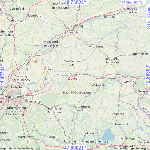
Dorfen GPS coordinates[2]
48° 16' 13.332" North, 12° 9' 38.016" East
| Map corner | latitude | longitude |
|---|---|---|
| Upper-left | 48.73624°, | 11.45744° |
| Center: | 48.27037°, | 12.16056° |
| Lower-right: | 47.80021°, | 12.86369° |
| Map W x H: | 104.1×104.1 km | = 64.7×64.7mi |
| max Lat: | 55.01917° ⇑91.6% North |
| Dorfen: | 48.27037° |
| min Lat: | ⇓8.4% South 47.40724° |
| min Long | Dorfen | max Long |
| 5.92978° | 12.16056° | 14.98853° |
| W 84%⇐ | ⇒16% E |
Elevation
Elevation of Dorfen is 443 m = 1453 ft, and this is 193.9 m = 636 ft above average elevation for this country.
| Max E: |
1256 m = 4121 ft | 18.6% |
| Dorfen | 443 m 1453 ft | |
| Avg. | 249.1 m = 817 ft | |
Min E: |
-5 m = -16 ft | 81.4% |
See also: Germany elevation on elevation.city.
Geographical zone
Dorfen is located in North temperate zone (between Tropic of Cancer and the Arctic Circle). Distance of this North polar circle is 2034 km =1263.9 mi to North.| Distance of | km | miles | from Dorfen |
|---|---|---|---|
| North Pole | 4639.9 | 2883.1 | to North |
| Arctic Circle | 2034 | 1263.9 | to North |
| Tropic Cancer | 2761.2 | 1715.7 | to South |
| Equator | 5367.2 | 3335 | to South |


Nearby cities:
15 places around Dorfen: (largest is in red/bold)
• Aham
8.7 km =5.4 mi,  0°
0°
• Buchbach
9.6 km =6 mi,  60°
60°
• Haag in Oberbayern
12.1 km =7.5 mi,  173°
173°
• Hohenpolding
12.7 km =7.9 mi,  350°
350°
• Inning am Holz
10.6 km =6.6 mi,  323°
323°
• Isen
10.1 km =6.3 mi,  229°
229°
• Kirchdorf
10.9 km =6.8 mi, 165°
• Lengdorf
8.3 km =5.2 mi,  260°
260°
• Obertaufkirchen
8.8 km =5.5 mi,  97°
97°
• Ramsau
12 km =7.5 mi,  154°
154°
• Rattenkirchen
11.9 km =7.4 mi,  105°
105°
• Reichertsheim
12 km =7.5 mi,  130°
130°
• Sankt Wolfgang
6.3 km =3.9 mi,  198°
198°
• Schwindegg
7.3 km =4.5 mi,  88°
88°
• Taufkirchen
9.1 km =5.7 mi, 346°
Sources, notices
• [Note1] Compared only with cities in Germany existing in our database
• [Src1] Map data: © OpenStreetMap contributors (CC-BY-SA)
• [Src2] Other city data from geonames.org with taken over terms of usage.
• [Src3] Geographical zone / Annual Mean Temperature by Robert A. Rohde @ Wikipedia
