Taufkirchen geodata
Taufkirchen (Bavaria) is a populated place; located in Germany in Europe/Berlin (GMT+2) time zone. With population of 8,690 people, there are 1846 cities with bigger population in this country. Compared to other cities in Germany, 90.7% of cities are located further ↑North; 83.6% of cities are located further ←West and 87.6% of cities have lower elevation than Taufkirchen. Note1
Administrative division(s):
- Level 1: Bavaria
- Level 2: Upper Bavaria
- Level 3: Landkreis Erding
- Level 4: Taufkirchen (Vils)


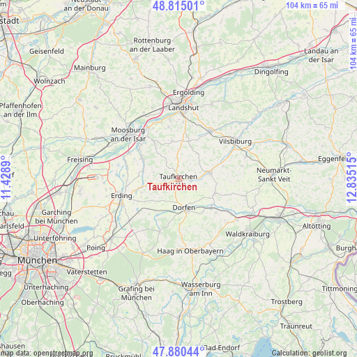
Taufkirchen GPS coordinates[2]
48° 20' 59.532" North, 12° 7' 55.272" East
| Map corner | latitude | longitude |
|---|---|---|
| Upper-left | 48.81501°, | 11.4289° |
| Center: | 48.34987°, | 12.13202° |
| Lower-right: | 47.88044°, | 12.83515° |
| Map W x H: | 103.9×103.9 km | = 64.6×64.6mi |
| max Lat: | 55.01917° ⇑90.7% North |
| Taufkirchen: | 48.34987° |
| min Lat: | ⇓9.3% South 47.40724° |
| min Long | Taufkirchen | max Long |
| 5.92978° | 12.13202° | 14.98853° |
| W 83.6%⇐ | ⇒16.4% E |
Elevation
Elevation of Taufkirchen is 490 m = 1608 ft, and this is 240.9 m = 790 ft above average elevation for this country.
| Max E: |
1256 m = 4121 ft | 12.4% |
| Taufkirchen | 490 m 1608 ft | |
| Avg. | 249.1 m = 817 ft | |
Min E: |
-5 m = -16 ft | 87.6% |
See also: Germany elevation on elevation.city.
Geographical zone
Taufkirchen is located in North temperate zone (between Tropic of Cancer and the Arctic Circle). Distance of this North polar circle is 2025.2 km =1258.4 mi to North.| Distance of | km | miles | from Taufkirchen |
|---|---|---|---|
| North Pole | 4631.1 | 2877.6 | to North |
| Arctic Circle | 2025.2 | 1258.4 | to North |
| Tropic Cancer | 2770.1 | 1721.3 | to South |
| Equator | 5376 | 3340.5 | to South |


Nearby cities:
15 places around Taufkirchen: (largest is in red/bold)
• Aham
2.2 km =1.4 mi,  94°
94°
• Altfraunhofen
11.4 km =7.1 mi,  12°
12°
• Baierbach
9 km =5.6 mi,  34°
34°
• Bockhorn
11.4 km =7.1 mi,  249°
249°
• Buchbach
11.3 km =7 mi,  111°
111°
• Dorfen
9.1 km =5.7 mi,  166°
166°
• Fraunberg
9.9 km =6.2 mi,  280°
280°
• Hohenpolding
3.7 km =2.3 mi,  1°
1°
• Inning am Holz
4.2 km =2.6 mi,  265°
265°
• Kirchberg
8.2 km =5.1 mi,  312°
312°
• Lengdorf
12 km =7.5 mi,  210°
210°
• Neufraunhofen
8.4 km =5.2 mi,  48°
48°
• Steinkirchen
5.2 km =3.2 mi,  315°
315°
• Velden
9.3 km =5.8 mi,  78°
78°
• Vilsheim
11.2 km =7 mi,  350°
350°
Sources, notices
• [Note1] Compared only with cities in Germany existing in our database
• [Src1] Map data: © OpenStreetMap contributors (CC-BY-SA)
• [Src2] Other city data from geonames.org with taken over terms of usage.
• [Src3] Geographical zone / Annual Mean Temperature by Robert A. Rohde @ Wikipedia
