Baierbach geodata
Baierbach (Bavaria) is a seat of a fourth-order administrative division; located in Germany in Europe/Berlin (GMT+2) time zone. With population of 774 people, there are 8006 cities with bigger population in this country. Compared to other cities in Germany, 90% of cities are located further ↑North; 84.6% of cities are located further ←West and 83.4% of cities have lower elevation than Baierbach. Note1
Administrative division(s):
- Level 1: Bavaria
- Level 2: Lower Bavaria
- Level 3: Landkreis Landshut
- Level 4: Baierbach


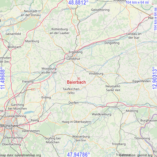
Baierbach GPS coordinates[2]
48° 25' 0.012" North, 12° 12' 0" East
| Map corner | latitude | longitude |
|---|---|---|
| Upper-left | 48.8812°, | 11.49688° |
| Center: | 48.41667°, | 12.2° |
| Lower-right: | 47.94786°, | 12.90313° |
| Map W x H: | 103.8×103.8 km | = 64.5×64.5mi |
| max Lat: | 55.01917° ⇑90% North |
| Baierbach: | 48.41667° |
| min Lat: | ⇓10% South 47.40724° |
| min Long | Baierbach | max Long |
| 5.92978° | 12.2° | 14.98853° |
| W 84.6%⇐ | ⇒15.4% E |
Elevation
Elevation of Baierbach is 457 m = 1499 ft, and this is 207.9 m = 682 ft above average elevation for this country.
| Max E: |
1256 m = 4121 ft | 16.6% |
| Baierbach | 457 m 1499 ft | |
| Avg. | 249.1 m = 817 ft | |
Min E: |
-5 m = -16 ft | 83.4% |
See also: Germany elevation on elevation.city.
Geographical zone
Baierbach is located in North temperate zone (between Tropic of Cancer and the Arctic Circle). Distance of this North polar circle is 2017.7 km =1253.7 mi to North.| Distance of | km | miles | from Baierbach |
|---|---|---|---|
| North Pole | 4623.6 | 2873 | to North |
| Arctic Circle | 2017.7 | 1253.7 | to North |
| Tropic Cancer | 2777.5 | 1725.9 | to South |
| Equator | 5383.4 | 3345.1 | to South |


Nearby cities:
15 places around Baierbach: (largest is in red/bold)
• Aham
8.1 km =5 mi,  200°
200°
• Altfraunhofen
4.4 km =2.7 mi,  326°
326°
• Eging
5.2 km =3.2 mi,  351°
351°
• Geisenhausen
7.9 km =4.9 mi,  32°
32°
• Hohenpolding
6.2 km =3.9 mi,  233°
233°
• Inning am Holz
12.1 km =7.5 mi, 229°
• Kirchberg
11.2 km =7 mi,  260°
260°
• Kumhausen
10.8 km =6.7 mi,  342°
342°
• Neufraunhofen
2.2 km =1.4 mi,  146°
146°
• Steinkirchen
9.4 km =5.8 mi,  246°
246°
• Taufkirchen
9 km =5.6 mi,  214°
214°
• Tiefenbach
11.8 km =7.3 mi,  321°
321°
• Velden
7 km =4.3 mi,  143°
143°
• Vilsbiburg
12.2 km =7.6 mi,  70°
70°
• Vilsheim
7.7 km =4.8 mi,  297°
297°
Sources, notices
• [Note1] Compared only with cities in Germany existing in our database
• [Src1] Map data: © OpenStreetMap contributors (CC-BY-SA)
• [Src2] Other city data from geonames.org with taken over terms of usage.
• [Src3] Geographical zone / Annual Mean Temperature by Robert A. Rohde @ Wikipedia
