Haag geodata
Haag (Bavaria) is a populated place; located in Germany in Europe/Berlin (GMT+2) time zone. With population of 959 people, there are 7312 cities with bigger population in this country. Compared to other cities in Germany, 56.6% of cities are located further ↑North; 82.9% of cities are located further ←West and 92.4% of cities have lower elevation than Haag. Note1
Administrative division(s):
- Level 1: Bavaria
- Level 2: Upper Franconia
- Level 3: Landkreis Hof
- Level 4: Regnitzlosau


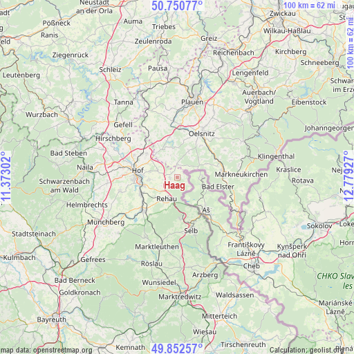
Haag GPS coordinates[2]
50° 18' 13.644" North, 12° 4' 34.104" East
| Map corner | latitude | longitude |
|---|---|---|
| Upper-left | 50.75077°, | 11.37302° |
| Center: | 50.30379°, | 12.07614° |
| Lower-right: | 49.85257°, | 12.77927° |
| Map W x H: | 99.9×99.9 km | = 62.1×62.1mi |
| max Lat: | 55.01917° ⇑56.6% North |
| Haag: | 50.30379° |
| min Lat: | ⇓43.4% South 47.40724° |
| min Long | Haag | max Long |
| 5.92978° | 12.07614° | 14.98853° |
| W 82.9%⇐ | ⇒17.1% E |
Elevation
Elevation of Haag is 549 m = 1801 ft, and this is 299.9 m = 984 ft above average elevation for this country.
| Max E: |
1256 m = 4121 ft | 7.6% |
| Haag | 549 m 1801 ft | |
| Avg. | 249.1 m = 817 ft | |
Min E: |
-5 m = -16 ft | 92.4% |
See also: Germany elevation on elevation.city.
Geographical zone
Haag is located in North temperate zone (between Tropic of Cancer and the Arctic Circle). Distance of this North polar circle is 1807.9 km =1123.4 mi to North.| Distance of | km | miles | from Haag |
|---|---|---|---|
| North Pole | 4413.8 | 2742.6 | to North |
| Arctic Circle | 1807.9 | 1123.4 | to North |
| Tropic Cancer | 2987.3 | 1856.2 | to South |
| Equator | 5593.3 | 3475.5 | to South |


Nearby cities:
15 places around Haag: (largest is in red/bold)
• Adorf
13.2 km =8.2 mi,  82°
82°
• Bad Elster
11.5 km =7.1 mi,  102°
102°
• Bösenbrunn
10.5 km =6.5 mi,  9°
9°
• Döhlau
9.2 km =5.7 mi,  255°
255°
• Eichigt
8.2 km =5.1 mi,  51°
51°
• Feilitzsch
12.3 km =7.6 mi,  304°
304°
• Gattendorf
5.9 km =3.7 mi,  290°
290°
• Hof
11.7 km =7.3 mi,  275°
275°
• Oberkotzau
11 km =6.8 mi,  245°
245°
• Regnitzlosau
1.9 km =1.2 mi, 257°
• Rehau
6.8 km =4.2 mi,  206°
206°
• Schwarzenbach an der Saale
13.5 km =8.4 mi,  228°
228°
• Schönwald
11.6 km =7.2 mi,  176°
176°
• Triebel
8.2 km =5.1 mi,  22°
22°
• Trogen
11.4 km =7.1 mi,  307°
307°
Sources, notices
• [Note1] Compared only with cities in Germany existing in our database
• [Src1] Map data: © OpenStreetMap contributors (CC-BY-SA)
• [Src2] Other city data from geonames.org with taken over terms of usage.
• [Src3] Geographical zone / Annual Mean Temperature by Robert A. Rohde @ Wikipedia
