Adenstedt geodata
Adenstedt (Lower Saxony) is a seat of a fourth-order administrative division; located in Germany in Europe/Berlin (GMT+2) time zone. With population of 1,020 people, there are 7118 cities with bigger population in this country. Compared to other cities in Germany, 72.2% of cities are located further ↓South; 50.9% of cities are located further →East and 52.9% of cities have higher elevation than Adenstedt. Note1


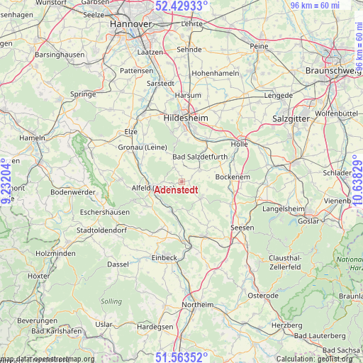
Adenstedt GPS coordinates[2]
51° 59' 54.672" North, 9° 56' 6.576" East
| Map corner | latitude | longitude |
|---|---|---|
| Upper-left | 52.42933°, | 9.23204° |
| Center: | 51.99852°, | 9.93516° |
| Lower-right: | 51.56352°, | 10.63829° |
| Map W x H: | 96.3×96.3 km | = 59.8×59.8mi |
| max Lat: | 55.01917° ⇑27.8% North |
| Adenstedt: | 51.99852° |
| min Lat: | ⇓72.2% South 47.40724° |
| min Long | Adenstedt | max Long |
| 5.92978° | 9.93516° | 14.98853° |
| W 49.1%⇐ | ⇒50.9% E |
Elevation
Elevation of Adenstedt is 205 m = 673 ft, and this is 44.1 m = 145 ft below average elevation for this country.
| Max E: |
1256 m = 4121 ft | 52.9% |
| Avg. | 249.1 m = 817 ft | |
| Adenstedt | 205 m = 673 ft | |
Min E: |
-5 m = -16 ft | 47.1% |
See also: Germany elevation on elevation.city.
Geographical zone
Adenstedt is located in North temperate zone (between Tropic of Cancer and the Arctic Circle). Distance of this North polar circle is 1619.5 km =1006.3 mi to North.| Distance of | km | miles | from Adenstedt |
|---|---|---|---|
| North Pole | 4225.4 | 2625.5 | to North |
| Arctic Circle | 1619.5 | 1006.3 | to North |
| Tropic Cancer | 3175.8 | 1973.4 | to South |
| Equator | 5781.7 | 3592.6 | to South |


Nearby cities:
15 places around Adenstedt: (largest is in red/bold)
• Alfeld
8.1 km =5 mi,  258°
258°
• Almstedt
4.2 km =2.6 mi,  25°
25°
• Bad Salzdetfurth
8.2 km =5.1 mi,  36°
36°
• Diekholzen
10.9 km =6.8 mi,  354°
354°
• Eberholzen
8.2 km =5.1 mi,  314°
314°
• Everode
5.5 km =3.4 mi,  193°
193°
• Freden
8.4 km =5.2 mi,  199°
199°
• Harbarnsen
2.7 km =1.7 mi,  128°
128°
• Lamspringe
6.7 km =4.2 mi, 128°
• Neuhof
8 km =5 mi,  102°
102°
• Sehlem
3.2 km =2 mi,  61°
61°
• Sibbesse
6.2 km =3.9 mi,  337°
337°
• Westfeld
5.9 km =3.7 mi, 347°
• Winzenburg
7.2 km =4.5 mi,  180°
180°
• Woltershausen
2 km =1.2 mi,  148°
148°
Sources, notices
• [Note1] Compared only with cities in Germany existing in our database
• [Src1] Map data: © OpenStreetMap contributors (CC-BY-SA)
• [Src2] Other city data from geonames.org with taken over terms of usage.
• [Src3] Geographical zone / Annual Mean Temperature by Robert A. Rohde @ Wikipedia
