Diekholzen geodata
Diekholzen (Lower Saxony) is a seat of a fourth-order administrative division; located in Germany in Europe/Berlin (GMT+2) time zone. With population of 6,941 people, there are 2200 cities with bigger population in this country. Compared to other cities in Germany, 73% of cities are located further ↓South; 51.1% of cities are located further →East and 64.7% of cities have higher elevation than Diekholzen. Note1


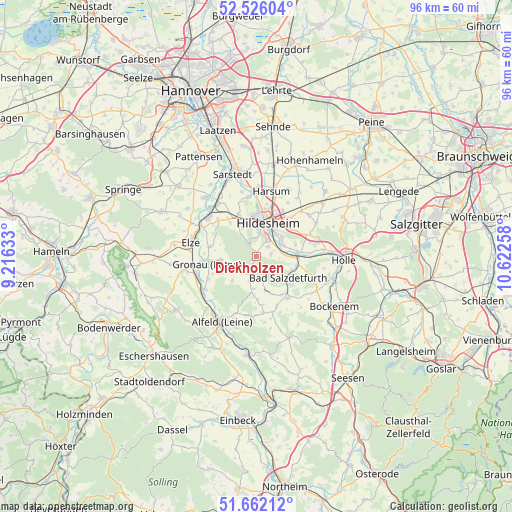
Diekholzen GPS coordinates[2]
52° 5' 46.212" North, 9° 55' 10.02" East
| Map corner | latitude | longitude |
|---|---|---|
| Upper-left | 52.52604°, | 9.21633° |
| Center: | 52.09617°, | 9.91945° |
| Lower-right: | 51.66212°, | 10.62258° |
| Map W x H: | 96.1×96.1 km | = 59.7×59.7mi |
| max Lat: | 55.01917° ⇑27% North |
| Diekholzen: | 52.09617° |
| min Lat: | ⇓73% South 47.40724° |
| min Long | Diekholzen | max Long |
| 5.92978° | 9.91945° | 14.98853° |
| W 48.9%⇐ | ⇒51.1% E |
Elevation
Elevation of Diekholzen is 122 m = 400 ft, and this is 127.1 m = 417 ft below average elevation for this country.
| Max E: |
1256 m = 4121 ft | 64.7% |
| Avg. | 249.1 m = 817 ft | |
| Diekholzen | 122 m = 400 ft | |
Min E: |
-5 m = -16 ft | 35.3% |
See also: Germany elevation on elevation.city.
Geographical zone
Diekholzen is located in North temperate zone (between Tropic of Cancer and the Arctic Circle). Distance of this North polar circle is 1608.6 km =999.5 mi to North.| Distance of | km | miles | from Diekholzen |
|---|---|---|---|
| North Pole | 4214.5 | 2618.8 | to North |
| Arctic Circle | 1608.6 | 999.5 | to North |
| Tropic Cancer | 3186.6 | 1980.1 | to South |
| Equator | 5792.6 | 3599.4 | to South |


Nearby cities:
15 places around Diekholzen: (largest is in red/bold)
• Adenstedt
10.9 km =6.8 mi,  174°
174°
• Almstedt
7.6 km =4.7 mi,  157°
157°
• Bad Salzdetfurth
7.3 km =4.5 mi,  125°
125°
• Betheln
8.8 km =5.5 mi,  283°
283°
• Brüggen
11.6 km =7.2 mi,  238°
238°
• Eberholzen
7 km =4.3 mi,  222°
222°
• Giesen
11.3 km =7 mi,  352°
352°
• Gronau
9.8 km =6.1 mi,  262°
262°
• Heyersum
9.9 km =6.2 mi,  312°
312°
• Hildesheim
6.4 km =4 mi,  19°
19°
• Nordstemmen
11.8 km =7.3 mi, 308°
• Rheden
10 km =6.2 mi, 244°
• Sehlem
10.1 km =6.3 mi, 157°
• Sibbesse
5.3 km =3.3 mi,  194°
194°
• Westfeld
5.1 km =3.2 mi,  182°
182°
Sources, notices
• [Note1] Compared only with cities in Germany existing in our database
• [Src1] Map data: © OpenStreetMap contributors (CC-BY-SA)
• [Src2] Other city data from geonames.org with taken over terms of usage.
• [Src3] Geographical zone / Annual Mean Temperature by Robert A. Rohde @ Wikipedia
