Freden geodata
Freden (Lower Saxony) is a populated place; located in Germany in Europe/Berlin (GMT+2) time zone. With population of 3,428 people, there are 3668 cities with bigger population in this country. Compared to other cities in Germany, 71.4% of cities are located further ↓South; 51.6% of cities are located further →East and 67.4% of cities have higher elevation than Freden. Note1
Administrative division(s):
- Level 1: Lower Saxony
- Level 3: Landkreis Hildesheim
- Level 4: Freden (Leine)


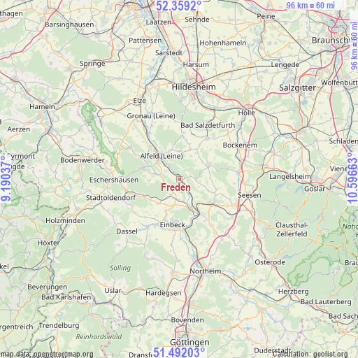
Freden GPS coordinates[2]
51° 55' 39.756" North, 9° 53' 36.6" East
| Map corner | latitude | longitude |
|---|---|---|
| Upper-left | 52.3592°, | 9.19037° |
| Center: | 51.92771°, | 9.8935° |
| Lower-right: | 51.49203°, | 10.59663° |
| Map W x H: | 96.4×96.4 km | = 59.9×59.9mi |
| max Lat: | 55.01917° ⇑28.6% North |
| Freden: | 51.92771° |
| min Lat: | ⇓71.4% South 47.40724° |
| min Long | Freden | max Long |
| 5.92978° | 9.8935° | 14.98853° |
| W 48.4%⇐ | ⇒51.6% E |
Elevation
Elevation of Freden is 105 m = 344 ft, and this is 144.1 m = 473 ft below average elevation for this country.
| Max E: |
1256 m = 4121 ft | 67.4% |
| Avg. | 249.1 m = 817 ft | |
| Freden | 105 m = 344 ft | |
Min E: |
-5 m = -16 ft | 32.6% |
See also: Germany elevation on elevation.city.
Geographical zone
Freden is located in North temperate zone (between Tropic of Cancer and the Arctic Circle). Distance of this North polar circle is 1627.4 km =1011.2 mi to North.| Distance of | km | miles | from Freden |
|---|---|---|---|
| North Pole | 4233.2 | 2630.4 | to North |
| Arctic Circle | 1627.4 | 1011.2 | to North |
| Tropic Cancer | 3167.9 | 1968.4 | to South |
| Equator | 5773.8 | 3587.7 | to South |


Nearby cities:
15 places around Freden: (largest is in red/bold)
• Adenstedt
8.4 km =5.2 mi,  19°
19°
• Alfeld
8 km =5 mi,  321°
321°
• Almstedt
12.5 km =7.8 mi, 21°
• Bad Gandersheim
11 km =6.8 mi,  124°
124°
• Delligsen
6.4 km =4 mi,  283°
283°
• Eimen
9 km =5.6 mi,  236°
236°
• Einbeck
12.1 km =7.5 mi,  187°
187°
• Everode
2.9 km =1.8 mi,  32°
32°
• Harbarnsen
8 km =5 mi,  39°
39°
• Kreiensen
9.6 km =6 mi,  149°
149°
• Lamspringe
8.9 km =5.5 mi,  65°
65°
• Neuhof
12.4 km =7.7 mi,  60°
60°
• Sehlem
11 km =6.8 mi, 30°
• Winzenburg
2.8 km =1.7 mi,  77°
77°
• Woltershausen
7.3 km =4.5 mi, 32°
Sources, notices
• [Note1] Compared only with cities in Germany existing in our database
• [Src1] Map data: © OpenStreetMap contributors (CC-BY-SA)
• [Src2] Other city data from geonames.org with taken over terms of usage.
• [Src3] Geographical zone / Annual Mean Temperature by Robert A. Rohde @ Wikipedia
