Seth geodata
Seth (Schleswig-Holstein) is a seat of a fourth-order administrative division; located in Germany in Europe/Berlin (GMT+2) time zone. With population of 2,026 people, there are 5031 cities with bigger population in this country. Compared to other cities in Germany, 90.6% of cities are located further ↓South; 52.9% of cities are located further ←West and 86.3% of cities have higher elevation than Seth. Note1


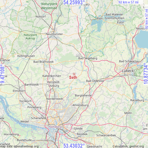
Seth GPS coordinates[2]
53° 50' 49.848" North, 10° 10' 27.156" East
| Map corner | latitude | longitude |
|---|---|---|
| Upper-left | 54.25993°, | 9.47108° |
| Center: | 53.84718°, | 10.17421° |
| Lower-right: | 53.43032°, | 10.87734° |
| Map W x H: | 92.2×92.2 km | = 57.3×57.3mi |
| max Lat: | 55.01917° ⇑9.4% North |
| Seth: | 53.84718° |
| min Lat: | ⇓90.6% South 47.40724° |
| min Long | Seth | max Long |
| 5.92978° | 10.17421° | 14.98853° |
| W 52.9%⇐ | ⇒47.1% E |
Elevation
Elevation of Seth is 32 m = 105 ft, and this is 217.1 m = 712 ft below average elevation for this country.
| Max E: |
1256 m = 4121 ft | 86.3% |
| Avg. | 249.1 m = 817 ft | |
| Seth | 32 m = 105 ft | |
Min E: |
-5 m = -16 ft | 13.7% |
See also: Germany elevation on elevation.city.
Geographical zone
Seth is located in North temperate zone (between Tropic of Cancer and the Arctic Circle). Distance of this North polar circle is 1413.9 km =878.6 mi to North.| Distance of | km | miles | from Seth |
|---|---|---|---|
| North Pole | 4019.8 | 2497.8 | to North |
| Arctic Circle | 1413.9 | 878.6 | to North |
| Tropic Cancer | 3381.3 | 2101 | to South |
| Equator | 5987.2 | 3720.3 | to South |


Nearby cities:
15 places around Seth: (largest is in red/bold)
• Bark
7.2 km =4.5 mi,  2°
2°
• Fredesdorf
3.5 km =2.2 mi,  25°
25°
• Groß Niendorf
4.5 km =2.8 mi,  91°
91°
• Hüttblek
7.2 km =4.5 mi,  257°
257°
• Itzstedt
4.5 km =2.8 mi,  193°
193°
• Kükels
7 km =4.3 mi, 33°
• Leezen
5.4 km =3.4 mi,  66°
66°
• Nahe
5.9 km =3.7 mi,  207°
207°
• Neversdorf
7.5 km =4.7 mi, 73°
• Nienwohld
6.8 km =4.2 mi,  168°
168°
• Sievershütten
4.1 km =2.5 mi, 262°
• Struvenhütten
8.4 km =5.2 mi,  284°
284°
• Stuvenborn
2.7 km =1.7 mi, 276°
• Sülfeld
6.5 km =4 mi,  143°
143°
• Todesfelde
5.9 km =3.7 mi,  5°
5°
Sources, notices
• [Note1] Compared only with cities in Germany existing in our database
• [Src1] Map data: © OpenStreetMap contributors (CC-BY-SA)
• [Src2] Other city data from geonames.org with taken over terms of usage.
• [Src3] Geographical zone / Annual Mean Temperature by Robert A. Rohde @ Wikipedia
