Stuvenborn geodata
Stuvenborn (Schleswig-Holstein) is a seat of a fourth-order administrative division; located in Germany in Europe/Berlin (GMT+2) time zone. With population of 893 people, there are 7548 cities with bigger population in this country. Compared to other cities in Germany, 90.6% of cities are located further ↓South; 52.2% of cities are located further ←West and 88.6% of cities have higher elevation than Stuvenborn. Note1


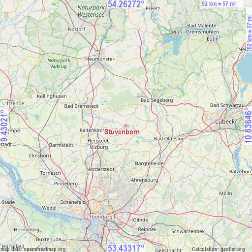
Stuvenborn GPS coordinates[2]
53° 51' 0" North, 10° 7' 59.988" East
| Map corner | latitude | longitude |
|---|---|---|
| Upper-left | 54.26272°, | 9.43021° |
| Center: | 53.85°, | 10.13333° |
| Lower-right: | 53.43317°, | 10.83646° |
| Map W x H: | 92.2×92.2 km | = 57.3×57.3mi |
| max Lat: | 55.01917° ⇑9.4% North |
| Stuvenborn: | 53.85° |
| min Lat: | ⇓90.6% South 47.40724° |
| min Long | Stuvenborn | max Long |
| 5.92978° | 10.13333° | 14.98853° |
| W 52.2%⇐ | ⇒47.8% E |
Elevation
Elevation of Stuvenborn is 25 m = 82 ft, and this is 224.1 m = 735 ft below average elevation for this country.
| Max E: |
1256 m = 4121 ft | 88.6% |
| Avg. | 249.1 m = 817 ft | |
| Stuvenborn | 25 m = 82 ft | |
Min E: |
-5 m = -16 ft | 11.4% |
See also: Germany elevation on elevation.city.
Geographical zone
Stuvenborn is located in North temperate zone (between Tropic of Cancer and the Arctic Circle). Distance of this North polar circle is 1413.6 km =878.4 mi to North.| Distance of | km | miles | from Stuvenborn |
|---|---|---|---|
| North Pole | 4019.5 | 2497.6 | to North |
| Arctic Circle | 1413.6 | 878.4 | to North |
| Tropic Cancer | 3381.6 | 2101.2 | to South |
| Equator | 5987.6 | 3720.5 | to South |


Nearby cities:
15 places around Stuvenborn: (largest is in red/bold)
• Bark
7.5 km =4.7 mi,  23°
23°
• Fredesdorf
5.1 km =3.2 mi,  55°
55°
• Groß Niendorf
7.2 km =4.5 mi,  93°
93°
• Hartenholm
7.2 km =4.5 mi,  318°
318°
• Hüttblek
4.7 km =2.9 mi,  247°
247°
• Itzstedt
4.9 km =3 mi,  160°
160°
• Kattendorf
7.3 km =4.5 mi,  264°
264°
• Leezen
7.9 km =4.9 mi,  76°
76°
• Nahe
5.6 km =3.5 mi,  180°
180°
• Nienwohld
8.1 km =5 mi,  150°
150°
• Seth
2.7 km =1.7 mi,  96°
96°
• Sievershütten
1.6 km =1 mi,  238°
238°
• Struvenhütten
5.8 km =3.6 mi,  288°
288°
• Todesfelde
6.5 km =4 mi,  30°
30°
• Winsen
7.9 km =4.9 mi, 256°
Sources, notices
• [Note1] Compared only with cities in Germany existing in our database
• [Src1] Map data: © OpenStreetMap contributors (CC-BY-SA)
• [Src2] Other city data from geonames.org with taken over terms of usage.
• [Src3] Geographical zone / Annual Mean Temperature by Robert A. Rohde @ Wikipedia
