Sievershütten geodata
Sievershütten (Schleswig-Holstein) is a seat of a fourth-order administrative division; located in Germany in Europe/Berlin (GMT+2) time zone. With population of 1,161 people, there are 6676 cities with bigger population in this country. Compared to other cities in Germany, 90.5% of cities are located further ↓South; 51.8% of cities are located further ←West and 88% of cities have higher elevation than Sievershütten. Note1
Administrative division(s):
- Level 1: Schleswig-Holstein
- Level 3: Kreis Segeberg
- Level 4: Sievershütten


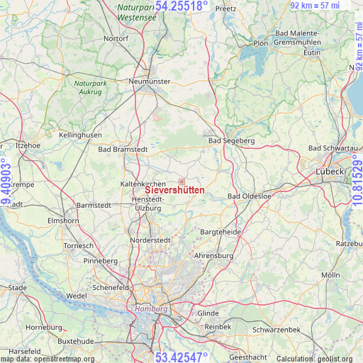
Sievershütten GPS coordinates[2]
53° 50' 32.568" North, 10° 6' 43.776" East
| Map corner | latitude | longitude |
|---|---|---|
| Upper-left | 54.25518°, | 9.40903° |
| Center: | 53.84238°, | 10.11216° |
| Lower-right: | 53.42547°, | 10.81529° |
| Map W x H: | 92.3×92.3 km | = 57.4×57.4mi |
| max Lat: | 55.01917° ⇑9.5% North |
| Sievershütten: | 53.84238° |
| min Lat: | ⇓90.5% South 47.40724° |
| min Long | Sievershütten | max Long |
| 5.92978° | 10.11216° | 14.98853° |
| W 51.8%⇐ | ⇒48.2% E |
Elevation
Elevation of Sievershütten is 27 m = 89 ft, and this is 222.1 m = 729 ft below average elevation for this country.
| Max E: |
1256 m = 4121 ft | 88% |
| Avg. | 249.1 m = 817 ft | |
| Sievershütten | 27 m = 89 ft | |
Min E: |
-5 m = -16 ft | 12% |
See also: Germany elevation on elevation.city.
Geographical zone
Sievershütten is located in North temperate zone (between Tropic of Cancer and the Arctic Circle). Distance of this North polar circle is 1414.5 km =878.9 mi to North.| Distance of | km | miles | from Sievershütten |
|---|---|---|---|
| North Pole | 4020.4 | 2498.2 | to North |
| Arctic Circle | 1414.5 | 878.9 | to North |
| Tropic Cancer | 3380.8 | 2100.7 | to South |
| Equator | 5986.7 | 3720 | to South |


Nearby cities:
15 places around Sievershütten: (largest is in red/bold)
• Fredesdorf
6.7 km =4.2 mi,  56°
56°
• Groß Niendorf
8.6 km =5.3 mi,  87°
87°
• Hartenholm
7.1 km =4.4 mi,  331°
331°
• Hüttblek
3.1 km =1.9 mi,  251°
251°
• Itzstedt
4.9 km =3 mi,  141°
141°
• Kattendorf
5.9 km =3.7 mi,  270°
270°
• Kisdorf
6.9 km =4.3 mi, 245°
• Nahe
4.9 km =3 mi,  163°
163°
• Nienwohld
8.2 km =5.1 mi, 138°
• Oersdorf
7.9 km =4.9 mi, 267°
• Seth
4.1 km =2.5 mi,  82°
82°
• Struvenhütten
4.9 km =3 mi,  303°
303°
• Stuvenborn
1.6 km =1 mi, 58°
• Todesfelde
7.9 km =4.9 mi,  36°
36°
• Winsen
6.3 km =3.9 mi,  260°
260°
Sources, notices
• [Note1] Compared only with cities in Germany existing in our database
• [Src1] Map data: © OpenStreetMap contributors (CC-BY-SA)
• [Src2] Other city data from geonames.org with taken over terms of usage.
• [Src3] Geographical zone / Annual Mean Temperature by Robert A. Rohde @ Wikipedia
