Altendorf geodata
Altendorf (Bavaria) is a seat of a fourth-order administrative division; located in Germany in Europe/Berlin (GMT+2) time zone. In our database, there are 11009 cities with bigger population. Compared to other cities in Germany, 69% of cities are located further ↑North; 67.2% of cities are located further ←West and 54.9% of cities have lower elevation than Altendorf. Note1
Administrative division(s):
- Level 1: Bavaria
- Level 2: Upper Franconia
- Level 3: Landkreis Bamberg
- Level 4: Altendorf


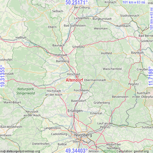
Altendorf GPS coordinates[2]
49° 48' 0" North, 11° 1' 0.012" East
| Map corner | latitude | longitude |
|---|---|---|
| Upper-left | 50.25171°, | 10.31355° |
| Center: | 49.8°, | 11.01667° |
| Lower-right: | 49.34403°, | 11.7198° |
| Map W x H: | 100.9×100.9 km | = 62.7×62.7mi |
| max Lat: | 55.01917° ⇑69% North |
| Altendorf: | 49.8° |
| min Lat: | ⇓31% South 47.40724° |
| min Long | Altendorf | max Long |
| 5.92978° | 11.01667° | 14.98853° |
| W 67.2%⇐ | ⇒32.8% E |
Elevation
Elevation of Altendorf is 257 m = 843 ft, and this is 7.9 m = 26 ft above average elevation for this country.
| Max E: |
1256 m = 4121 ft | 45.1% |
| Altendorf | 257 m 843 ft | |
| Avg. | 249.1 m = 817 ft | |
Min E: |
-5 m = -16 ft | 54.9% |
See also: Germany elevation on elevation.city.
Geographical zone
Altendorf is located in North temperate zone (between Tropic of Cancer and the Arctic Circle). Distance of this North polar circle is 1863.9 km =1158.2 mi to North.| Distance of | km | miles | from Altendorf |
|---|---|---|---|
| North Pole | 4469.8 | 2777.4 | to North |
| Arctic Circle | 1863.9 | 1158.2 | to North |
| Tropic Cancer | 2931.3 | 1821.4 | to South |
| Equator | 5537.2 | 3440.7 | to South |


Nearby cities:
15 places around Altendorf: (largest is in red/bold)
• Buttenheim
1 km =0.6 mi,  67°
67°
• Ebermannstadt
12 km =7.5 mi,  99°
99°
• Eggolsheim
4.5 km =2.8 mi,  139°
139°
• Forchheim
9.7 km =6 mi,  161°
161°
• Frensdorf
10.9 km =6.8 mi,  279°
279°
• Hallerndorf
5.3 km =3.3 mi,  210°
210°
• Hausen
12.3 km =7.6 mi,  174°
174°
• Heroldsbach
11.9 km =7.4 mi,  186°
186°
• Hirschaid
2.8 km =1.7 mi,  315°
315°
• Kirchehrenbach
12.1 km =7.5 mi,  127°
127°
• Pettstadt
7.2 km =4.5 mi,  297°
297°
• Pretzfeld
12.4 km =7.7 mi,  114°
114°
• Strullendorf
5.9 km =3.7 mi,  326°
326°
• Unterleinleiter
12.6 km =7.8 mi,  78°
78°
• Weilersbach
9.1 km =5.7 mi, 127°
Sources, notices
• [Note1] Compared only with cities in Germany existing in our database
• [Src1] Map data: © OpenStreetMap contributors (CC-BY-SA)
• [Src2] Other city data from geonames.org with taken over terms of usage.
• [Src3] Geographical zone / Annual Mean Temperature by Robert A. Rohde @ Wikipedia
