Buttenheim geodata
Buttenheim (Bavaria) is a populated place; located in Germany in Europe/Berlin (GMT+2) time zone. With population of 3,242 people, there are 3794 cities with bigger population in this country. Compared to other cities in Germany, 68.8% of cities are located further ↑North; 67.4% of cities are located further ←West and 56.7% of cities have lower elevation than Buttenheim. Note1
Administrative division(s):
- Level 1: Bavaria
- Level 2: Upper Franconia
- Level 3: Landkreis Bamberg
- Level 4: Buttenheim, Markt


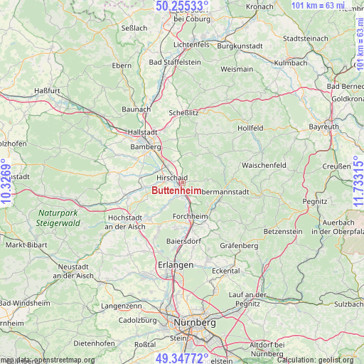
Buttenheim GPS coordinates[2]
49° 48' 13.14" North, 11° 1' 48.072" East
| Map corner | latitude | longitude |
|---|---|---|
| Upper-left | 50.25533°, | 10.3269° |
| Center: | 49.80365°, | 11.03002° |
| Lower-right: | 49.34772°, | 11.73315° |
| Map W x H: | 100.9×100.9 km | = 62.7×62.7mi |
| max Lat: | 55.01917° ⇑68.8% North |
| Buttenheim: | 49.80365° |
| min Lat: | ⇓31.2% South 47.40724° |
| min Long | Buttenheim | max Long |
| 5.92978° | 11.03002° | 14.98853° |
| W 67.4%⇐ | ⇒32.6% E |
Elevation
Elevation of Buttenheim is 270 m = 886 ft, and this is 20.9 m = 69 ft above average elevation for this country.
| Max E: |
1256 m = 4121 ft | 43.3% |
| Buttenheim | 270 m 886 ft | |
| Avg. | 249.1 m = 817 ft | |
Min E: |
-5 m = -16 ft | 56.7% |
See also: Germany elevation on elevation.city.
Geographical zone
Buttenheim is located in North temperate zone (between Tropic of Cancer and the Arctic Circle). Distance of this North polar circle is 1863.5 km =1157.9 mi to North.| Distance of | km | miles | from Buttenheim |
|---|---|---|---|
| North Pole | 4469.4 | 2777.2 | to North |
| Arctic Circle | 1863.5 | 1157.9 | to North |
| Tropic Cancer | 2931.7 | 1821.7 | to South |
| Equator | 5537.6 | 3440.9 | to South |


Nearby cities:
15 places around Buttenheim: (largest is in red/bold)
• Altendorf
1 km =0.6 mi,  247°
247°
• Ebermannstadt
11.2 km =7 mi,  102°
102°
• Eggolsheim
4.3 km =2.7 mi,  152°
152°
• Forchheim
9.8 km =6.1 mi,  167°
167°
• Frensdorf
11.8 km =7.3 mi,  277°
277°
• Hallerndorf
6.1 km =3.8 mi,  216°
216°
• Heiligenstadt
12.1 km =7.5 mi,  57°
57°
• Hirschaid
3.3 km =2.1 mi,  298°
298°
• Kirchehrenbach
11.6 km =7.2 mi,  132°
132°
• Litzendorf
12.4 km =7.7 mi,  353°
353°
• Pettstadt
7.9 km =4.9 mi,  291°
291°
• Pretzfeld
11.7 km =7.3 mi,  117°
117°
• Strullendorf
6.1 km =3.8 mi,  317°
317°
• Unterleinleiter
11.6 km =7.2 mi,  79°
79°
• Weilersbach
8.6 km =5.3 mi, 133°
Sources, notices
• [Note1] Compared only with cities in Germany existing in our database
• [Src1] Map data: © OpenStreetMap contributors (CC-BY-SA)
• [Src2] Other city data from geonames.org with taken over terms of usage.
• [Src3] Geographical zone / Annual Mean Temperature by Robert A. Rohde @ Wikipedia
