Saara geodata
Saara (Thuringia) is a seat of a fourth-order administrative division; located in Germany in Europe/Berlin (GMT+2) time zone. With population of 679 people, there are 8428 cities with bigger population in this country. Compared to other cities in Germany, 55% of cities are located further ↓South; 81.4% of cities are located further ←West and 61.1% of cities have lower elevation than Saara. Note1


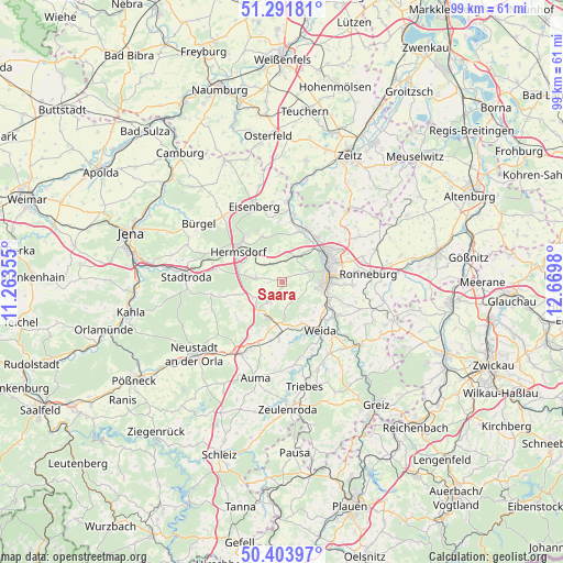
Saara GPS coordinates[2]
50° 51' 0" North, 11° 58' 0.012" East
| Map corner | latitude | longitude |
|---|---|---|
| Upper-left | 51.29181°, | 11.26355° |
| Center: | 50.85°, | 11.96667° |
| Lower-right: | 50.40397°, | 12.6698° |
| Map W x H: | 98.7×98.7 km | = 61.3×61.3mi |
| max Lat: | 55.01917° ⇑45% North |
| Saara: | 50.85° |
| min Lat: | ⇓55% South 47.40724° |
| min Long | Saara | max Long |
| 5.92978° | 11.96667° | 14.98853° |
| W 81.4%⇐ | ⇒18.6% E |
Elevation
Elevation of Saara is 296 m = 971 ft, and this is 46.9 m = 154 ft above average elevation for this country.
| Max E: |
1256 m = 4121 ft | 38.9% |
| Saara | 296 m 971 ft | |
| Avg. | 249.1 m = 817 ft | |
Min E: |
-5 m = -16 ft | 61.1% |
See also: Germany elevation on elevation.city.
Geographical zone
Saara is located in North temperate zone (between Tropic of Cancer and the Arctic Circle). Distance of this North polar circle is 1747.2 km =1085.7 mi to North.| Distance of | km | miles | from Saara |
|---|---|---|---|
| North Pole | 4353.1 | 2704.9 | to North |
| Arctic Circle | 1747.2 | 1085.7 | to North |
| Tropic Cancer | 3048.1 | 1894 | to South |
| Equator | 5654 | 3513.2 | to South |


Nearby cities:
15 places around Saara: (largest is in red/bold)
• Bocka
3.7 km =2.3 mi,  180°
180°
• Crimla
8.1 km =5 mi,  133°
133°
• Eineborn
7.3 km =4.5 mi,  255°
255°
• Gera
8.8 km =5.5 mi,  67°
67°
• Hartmannsdorf
6 km =3.7 mi,  22°
22°
• Hundhaupten
2.2 km =1.4 mi,  147°
147°
• Kraftsdorf
3.9 km =2.4 mi,  317°
317°
• Lederhose
6.6 km =4.1 mi,  212°
212°
• Lindenkreuz
3.5 km =2.2 mi,  270°
270°
• Münchenbernsdorf
4 km =2.5 mi,  216°
216°
• Reichenbach
6.6 km =4.1 mi,  288°
288°
• Sankt Gangloff
5.1 km =3.2 mi,  276°
276°
• Schwarzbach
8.7 km =5.4 mi,  227°
227°
• Tautendorf
6 km =3.7 mi, 231°
• Zedlitz
6 km =3.7 mi, 128°
Sources, notices
• [Note1] Compared only with cities in Germany existing in our database
• [Src1] Map data: © OpenStreetMap contributors (CC-BY-SA)
• [Src2] Other city data from geonames.org with taken over terms of usage.
• [Src3] Geographical zone / Annual Mean Temperature by Robert A. Rohde @ Wikipedia
