Gera geodata
Gera (Thuringia) is a seat of a third-order administrative division; located in Germany in Europe/Berlin (GMT+2) time zone. With population of 104,659 people, there are 92 cities with bigger population in this country. Compared to other cities in Germany, 55.7% of cities are located further ↓South; 82.9% of cities are located further ←West and 53.1% of cities have higher elevation than Gera. Note1


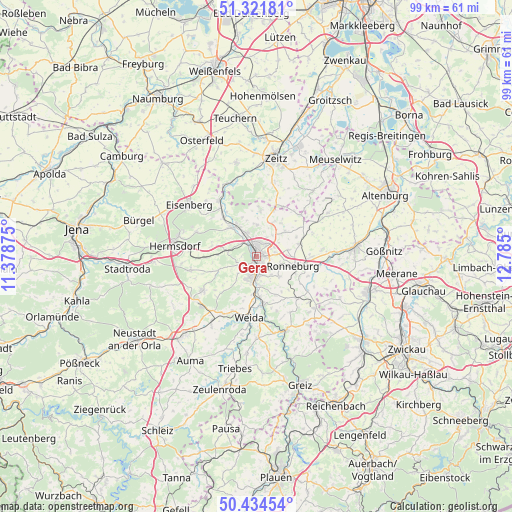
Gera GPS coordinates[2]
50° 52' 49.044" North, 12° 4' 54.732" East
| Map corner | latitude | longitude |
|---|---|---|
| Upper-left | 51.32181°, | 11.37875° |
| Center: | 50.88029°, | 12.08187° |
| Lower-right: | 50.43454°, | 12.785° |
| Map W x H: | 98.7×98.7 km | = 61.3×61.3mi |
| max Lat: | 55.01917° ⇑44.3% North |
| Gera: | 50.88029° |
| min Lat: | ⇓55.7% South 47.40724° |
| min Long | Gera | max Long |
| 5.92978° | 12.08187° | 14.98853° |
| W 82.9%⇐ | ⇒17.1% E |
Elevation
Elevation of Gera is 203 m = 666 ft, and this is 46.1 m = 151 ft below average elevation for this country.
| Max E: |
1256 m = 4121 ft | 53.1% |
| Avg. | 249.1 m = 817 ft | |
| Gera | 203 m = 666 ft | |
Min E: |
-5 m = -16 ft | 46.9% |
See also: Gera elevation on elevation.city.
Geographical zone
Gera is located in North temperate zone (between Tropic of Cancer and the Arctic Circle). Distance of this North polar circle is 1743.8 km =1083.5 mi to North.| Distance of | km | miles | from Gera |
|---|---|---|---|
| North Pole | 4349.7 | 2702.8 | to North |
| Arctic Circle | 1743.8 | 1083.5 | to North |
| Tropic Cancer | 3051.4 | 1896.1 | to South |
| Equator | 5657.4 | 3515.3 | to South |


Nearby cities:
15 places around Gera: (largest is in red/bold)
• Bad Köstritz
7.5 km =4.7 mi,  317°
317°
• Brahmenau
7.2 km =4.5 mi,  48°
48°
• Caaschwitz
9.6 km =6 mi, 323°
• Crimla
9.2 km =5.7 mi,  194°
194°
• Großenstein
8.6 km =5.3 mi,  75°
75°
• Hartmannsdorf
6.1 km =3.8 mi,  290°
290°
• Hilbersdorf
8.5 km =5.3 mi,  145°
145°
• Hundhaupten
8.7 km =5.4 mi,  232°
232°
• Korbussen
6.4 km =4 mi, 79°
• Ronneburg
7.6 km =4.7 mi,  104°
104°
• Saara
8.8 km =5.5 mi,  247°
247°
• Schwaara
5 km =3.1 mi,  59°
59°
• Silbitz
9.6 km =6 mi, 323°
• Wünschendorf
9.4 km =5.8 mi,  172°
172°
• Zedlitz
7.9 km =4.9 mi,  205°
205°
Sources, notices
• [Note1] Compared only with cities in Germany existing in our database
• [Src1] Map data: © OpenStreetMap contributors (CC-BY-SA)
• [Src2] Other city data from geonames.org with taken over terms of usage.
• [Src3] Geographical zone / Annual Mean Temperature by Robert A. Rohde @ Wikipedia
