Kraftsdorf geodata
Kraftsdorf (Thuringia) is a seat of a fourth-order administrative division; located in Germany in Europe/Berlin (GMT+2) time zone. With population of 4,403 people, there are 3092 cities with bigger population in this country. Compared to other cities in Germany, 55.6% of cities are located further ↓South; 80.7% of cities are located further ←West and 54.9% of cities have lower elevation than Kraftsdorf. Note1


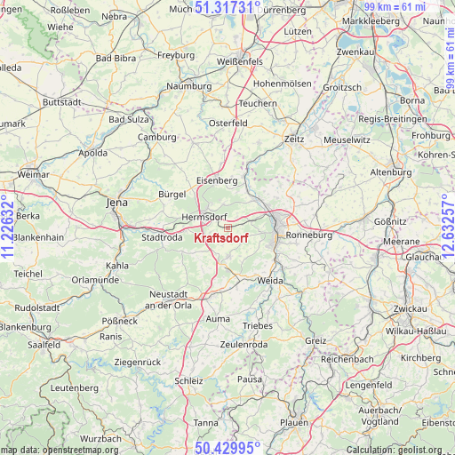
Kraftsdorf GPS coordinates[2]
50° 52' 32.664" North, 11° 55' 45.984" East
| Map corner | latitude | longitude |
|---|---|---|
| Upper-left | 51.31731°, | 11.22632° |
| Center: | 50.87574°, | 11.92944° |
| Lower-right: | 50.42995°, | 12.63257° |
| Map W x H: | 98.7×98.7 km | = 61.3×61.3mi |
| max Lat: | 55.01917° ⇑44.4% North |
| Kraftsdorf: | 50.87574° |
| min Lat: | ⇓55.6% South 47.40724° |
| min Long | Kraftsdorf | max Long |
| 5.92978° | 11.92944° | 14.98853° |
| W 80.7%⇐ | ⇒19.3% E |
Elevation
Elevation of Kraftsdorf is 257 m = 843 ft, and this is 7.9 m = 26 ft above average elevation for this country.
| Max E: |
1256 m = 4121 ft | 45.1% |
| Kraftsdorf | 257 m 843 ft | |
| Avg. | 249.1 m = 817 ft | |
Min E: |
-5 m = -16 ft | 54.9% |
See also: Germany elevation on elevation.city.
Geographical zone
Kraftsdorf is located in North temperate zone (between Tropic of Cancer and the Arctic Circle). Distance of this North polar circle is 1744.3 km =1083.9 mi to North.| Distance of | km | miles | from Kraftsdorf |
|---|---|---|---|
| North Pole | 4350.2 | 2703.1 | to North |
| Arctic Circle | 1744.3 | 1083.9 | to North |
| Tropic Cancer | 3050.9 | 1895.7 | to South |
| Equator | 5656.9 | 3515 | to South |


Nearby cities:
15 places around Kraftsdorf: (largest is in red/bold)
• Bad Klosterlausnitz
6.3 km =3.9 mi,  315°
315°
• Bocka
7.1 km =4.4 mi,  158°
158°
• Eineborn
6.5 km =4 mi,  223°
223°
• Hartmannsdorf
5.6 km =3.5 mi,  61°
61°
• Hermsdorf
5.7 km =3.5 mi,  294°
294°
• Hundhaupten
6 km =3.7 mi,  141°
141°
• Lindenkreuz
3 km =1.9 mi,  197°
197°
• Münchenbernsdorf
6.1 km =3.8 mi,  178°
178°
• Reichenbach
3.7 km =2.3 mi,  257°
257°
• Saara
3.9 km =2.4 mi, 137°
• Sankt Gangloff
3.4 km =2.1 mi,  227°
227°
• Schleifreisen
8 km =5 mi,  276°
276°
• Tautendorf
6.9 km =4.3 mi, 197°
• Tautenhain
5.5 km =3.4 mi,  352°
352°
• Weißenborn
6.4 km =4 mi,  326°
326°
Sources, notices
• [Note1] Compared only with cities in Germany existing in our database
• [Src1] Map data: © OpenStreetMap contributors (CC-BY-SA)
• [Src2] Other city data from geonames.org with taken over terms of usage.
• [Src3] Geographical zone / Annual Mean Temperature by Robert A. Rohde @ Wikipedia
