Lindenkreuz geodata
Lindenkreuz (Thuringia) is a seat of a fourth-order administrative division; located in Germany in Europe/Berlin (GMT+2) time zone. With population of 511 people, there are 9318 cities with bigger population in this country. Compared to other cities in Germany, 55% of cities are located further ↓South; 80.5% of cities are located further ←West and 63.3% of cities have lower elevation than Lindenkreuz. Note1


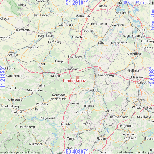
Lindenkreuz GPS coordinates[2]
50° 51' 0" North, 11° 55' 0.012" East
| Map corner | latitude | longitude |
|---|---|---|
| Upper-left | 51.29181°, | 11.21355° |
| Center: | 50.85°, | 11.91667° |
| Lower-right: | 50.40397°, | 12.6198° |
| Map W x H: | 98.7×98.7 km | = 61.3×61.3mi |
| max Lat: | 55.01917° ⇑45% North |
| Lindenkreuz: | 50.85° |
| min Lat: | ⇓55% South 47.40724° |
| min Long | Lindenkreuz | max Long |
| 5.92978° | 11.91667° | 14.98853° |
| W 80.5%⇐ | ⇒19.5% E |
Elevation
Elevation of Lindenkreuz is 310 m = 1017 ft, and this is 60.9 m = 200 ft above average elevation for this country.
| Max E: |
1256 m = 4121 ft | 36.7% |
| Lindenkreuz | 310 m 1017 ft | |
| Avg. | 249.1 m = 817 ft | |
Min E: |
-5 m = -16 ft | 63.3% |
See also: Germany elevation on elevation.city.
Geographical zone
Lindenkreuz is located in North temperate zone (between Tropic of Cancer and the Arctic Circle). Distance of this North polar circle is 1747.2 km =1085.7 mi to North.| Distance of | km | miles | from Lindenkreuz |
|---|---|---|---|
| North Pole | 4353.1 | 2704.9 | to North |
| Arctic Circle | 1747.2 | 1085.7 | to North |
| Tropic Cancer | 3048.1 | 1894 | to South |
| Equator | 5654 | 3513.2 | to South |


Nearby cities:
15 places around Lindenkreuz: (largest is in red/bold)
• Bocka
5.1 km =3.2 mi,  136°
136°
• Eineborn
4 km =2.5 mi,  242°
242°
• Hermsdorf
6.8 km =4.2 mi,  320°
320°
• Hundhaupten
5 km =3.1 mi,  111°
111°
• Kleinebersdorf
6.9 km =4.3 mi, 237°
• Kraftsdorf
3 km =1.9 mi,  17°
17°
• Lederhose
5.6 km =3.5 mi,  180°
180°
• Münchenbernsdorf
3.4 km =2.1 mi,  161°
161°
• Ottendorf
6.9 km =4.3 mi,  248°
248°
• Reichenbach
3.4 km =2.1 mi,  307°
307°
• Renthendorf
7.4 km =4.6 mi,  221°
221°
• Saara
3.5 km =2.2 mi,  90°
90°
• Sankt Gangloff
1.7 km =1.1 mi,  290°
290°
• Schwarzbach
6.6 km =4.1 mi,  206°
206°
• Tautendorf
3.9 km =2.4 mi,  197°
197°
Sources, notices
• [Note1] Compared only with cities in Germany existing in our database
• [Src1] Map data: © OpenStreetMap contributors (CC-BY-SA)
• [Src2] Other city data from geonames.org with taken over terms of usage.
• [Src3] Geographical zone / Annual Mean Temperature by Robert A. Rohde @ Wikipedia
