Melsungen geodata
Melsungen (Hesse) is a populated place; located in Germany in Europe/Berlin (GMT+2) time zone. With population of 14,004 people, there are 1136 cities with bigger population in this country. Compared to other cities in Germany, 60.4% of cities are located further ↓South; 57% of cities are located further →East and 56.3% of cities have higher elevation than Melsungen. Note1
Administrative division(s):
- Level 1: Hesse
- Level 2: Regierungsbezirk Kassel
- Level 3: Schwalm-Eder-Kreis
- Level 4: Melsungen


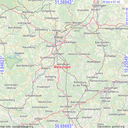
Melsungen GPS coordinates[2]
51° 7' 49.044" North, 9° 33' 8.496" East
| Map corner | latitude | longitude |
|---|---|---|
| Upper-left | 51.56943°, | 8.84923° |
| Center: | 51.13029°, | 9.55236° |
| Lower-right: | 50.68693°, | 10.25549° |
| Map W x H: | 98.1×98.1 km | = 61×61mi |
| max Lat: | 55.01917° ⇑39.6% North |
| Melsungen: | 51.13029° |
| min Lat: | ⇓60.4% South 47.40724° |
| min Long | Melsungen | max Long |
| 5.92978° | 9.55236° | 14.98853° |
| W 43%⇐ | ⇒57% E |
Elevation
Elevation of Melsungen is 179 m = 587 ft, and this is 70.1 m = 230 ft below average elevation for this country.
| Max E: |
1256 m = 4121 ft | 56.3% |
| Avg. | 249.1 m = 817 ft | |
| Melsungen | 179 m = 587 ft | |
Min E: |
-5 m = -16 ft | 43.7% |
See also: Germany elevation on elevation.city.
Geographical zone
Melsungen is located in North temperate zone (between Tropic of Cancer and the Arctic Circle). Distance of this North polar circle is 1716 km =1066.3 mi to North.| Distance of | km | miles | from Melsungen |
|---|---|---|---|
| North Pole | 4321.9 | 2685.5 | to North |
| Arctic Circle | 1716 | 1066.3 | to North |
| Tropic Cancer | 3079.2 | 1913.3 | to South |
| Equator | 5685.2 | 3532.6 | to South |


Nearby cities:
15 places around Melsungen: (largest is in red/bold)
• Alheim
13.4 km =8.3 mi,  143°
143°
• Baunatal
16.9 km =10.5 mi,  323°
323°
• Felsberg
9.2 km =5.7 mi,  275°
275°
• Fuldabrück
15.9 km =9.9 mi,  342°
342°
• Gudensberg
13.9 km =8.6 mi,  291°
291°
• Guxhagen
9.1 km =5.7 mi,  328°
328°
• Helsa
17.3 km =10.7 mi,  33°
33°
• Hessisch Lichtenau
13.9 km =8.6 mi,  56°
56°
• Homberg
15.3 km =9.5 mi,  223°
223°
• Kaufungen
17.4 km =10.8 mi,  15°
15°
• Körle
4.7 km =2.9 mi, 328°
• Lohfelden
15.2 km =9.4 mi,  355°
355°
• Malsfeld
4.5 km =2.8 mi,  192°
192°
• Spangenberg
7.9 km =4.9 mi,  101°
101°
• Wabern
14.5 km =9 mi,  256°
256°
Sources, notices
• [Note1] Compared only with cities in Germany existing in our database
• [Src1] Map data: © OpenStreetMap contributors (CC-BY-SA)
• [Src2] Other city data from geonames.org with taken over terms of usage.
• [Src3] Geographical zone / Annual Mean Temperature by Robert A. Rohde @ Wikipedia
