Jettingen-Scheppach geodata
Jettingen-Scheppach (Bavaria) is a populated place; located in Germany in Europe/Berlin (GMT+2) time zone. With population of 6,865 people, there are 2214 cities with bigger population in this country. Compared to other cities in Germany, 90.3% of cities are located further ↑North; 57.9% of cities are located further ←West and 85.3% of cities have lower elevation than Jettingen-Scheppach. Note1
Administrative division(s):
- Level 1: Bavaria
- Level 2: Swabia
- Level 3: Landkreis Günzburg
- Level 4: Jettingen-Scheppach, Markt


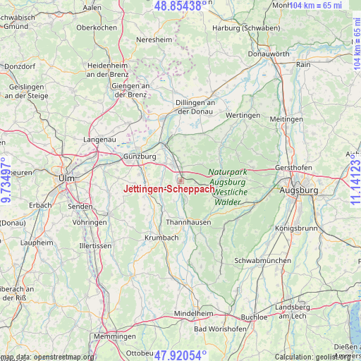
Jettingen-Scheppach GPS coordinates[2]
48° 23' 22.56" North, 10° 26' 17.16" East
| Map corner | latitude | longitude |
|---|---|---|
| Upper-left | 48.85438°, | 9.73497° |
| Center: | 48.3896°, | 10.4381° |
| Lower-right: | 47.92054°, | 11.14123° |
| Map W x H: | 103.8×103.8 km | = 64.5×64.5mi |
| max Lat: | 55.01917° ⇑90.3% North |
| Jettingen-Scheppach: | 48.3896° |
| min Lat: | ⇓9.7% South 47.40724° |
| min Long | Jettingen-Schep | max Long |
| 5.92978° | 10.4381° | 14.98853° |
| W 57.9%⇐ | ⇒42.1% E |
Elevation
Elevation of Jettingen-Scheppach is 472 m = 1549 ft, and this is 222.9 m = 731 ft above average elevation for this country.
| Max E: |
1256 m = 4121 ft | 14.7% |
| Jettingen-Scheppach | 472 m 1549 ft | |
| Avg. | 249.1 m = 817 ft | |
Min E: |
-5 m = -16 ft | 85.3% |
See also: Germany elevation on elevation.city.
Geographical zone
Jettingen-Scheppach is located in North temperate zone (between Tropic of Cancer and the Arctic Circle). Distance of this North polar circle is 2020.8 km =1255.7 mi to North.| Distance of | km | miles | from Jettingen-Scheppach |
|---|---|---|---|
| North Pole | 4626.6 | 2874.8 | to North |
| Arctic Circle | 2020.8 | 1255.7 | to North |
| Tropic Cancer | 2774.5 | 1724 | to South |
| Equator | 5380.4 | 3343.2 | to South |


Nearby cities:
15 places around Jettingen-Scheppach: (largest is in red/bold)
• Burgau
5.1 km =3.2 mi,  335°
335°
• Burtenbach
5.6 km =3.5 mi,  168°
168°
• Dürrlauingen
8.6 km =5.3 mi,  355°
355°
• Ellzee
10.4 km =6.5 mi,  237°
237°
• Haldenwang
5.4 km =3.4 mi,  7°
7°
• Ichenhausen
9.9 km =6.2 mi,  258°
258°
• Landensberg
8.1 km =5 mi,  51°
51°
• Münsterhausen
9 km =5.6 mi, 171°
• Offingen
11.7 km =7.3 mi,  331°
331°
• Rettenbach
10 km =6.2 mi,  320°
320°
• Roßhaupten
5 km =3.1 mi,  27°
27°
• Röfingen
3.9 km =2.4 mi,  4°
4°
• Waldstetten
11.6 km =7.2 mi,  246°
246°
• Winterbach
9.2 km =5.7 mi,  21°
21°
• Zusmarshausen
11.9 km =7.4 mi,  84°
84°
Sources, notices
• [Note1] Compared only with cities in Germany existing in our database
• [Src1] Map data: © OpenStreetMap contributors (CC-BY-SA)
• [Src2] Other city data from geonames.org with taken over terms of usage.
• [Src3] Geographical zone / Annual Mean Temperature by Robert A. Rohde @ Wikipedia
