Ichenhausen geodata
Ichenhausen (Bavaria) is a populated place; located in Germany in Europe/Berlin (GMT+2) time zone. With population of 8,499 people, there are 1875 cities with bigger population in this country. Compared to other cities in Germany, 90.5% of cities are located further ↑North; 55.5% of cities are located further ←West and 87.8% of cities have lower elevation than Ichenhausen. Note1
Administrative division(s):
- Level 1: Bavaria
- Level 2: Swabia
- Level 3: Landkreis Günzburg
- Level 4: Ichenhausen


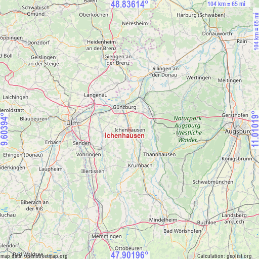
Ichenhausen GPS coordinates[2]
48° 22' 16.284" North, 10° 18' 25.416" East
| Map corner | latitude | longitude |
|---|---|---|
| Upper-left | 48.83614°, | 9.60394° |
| Center: | 48.37119°, | 10.30706° |
| Lower-right: | 47.90196°, | 11.01019° |
| Map W x H: | 103.9×103.9 km | = 64.6×64.6mi |
| max Lat: | 55.01917° ⇑90.5% North |
| Ichenhausen: | 48.37119° |
| min Lat: | ⇓9.5% South 47.40724° |
| min Long | Ichenhausen | max Long |
| 5.92978° | 10.30706° | 14.98853° |
| W 55.5%⇐ | ⇒44.5% E |
Elevation
Elevation of Ichenhausen is 492 m = 1614 ft, and this is 242.9 m = 797 ft above average elevation for this country.
| Max E: |
1256 m = 4121 ft | 12.2% |
| Ichenhausen | 492 m 1614 ft | |
| Avg. | 249.1 m = 817 ft | |
Min E: |
-5 m = -16 ft | 87.8% |
See also: Germany elevation on elevation.city.
Geographical zone
Ichenhausen is located in North temperate zone (between Tropic of Cancer and the Arctic Circle). Distance of this North polar circle is 2022.8 km =1256.9 mi to North.| Distance of | km | miles | from Ichenhausen |
|---|---|---|---|
| North Pole | 4628.7 | 2876.1 | to North |
| Arctic Circle | 2022.8 | 1256.9 | to North |
| Tropic Cancer | 2772.5 | 1722.8 | to South |
| Equator | 5378.4 | 3342 | to South |


Nearby cities:
15 places around Ichenhausen: (largest is in red/bold)
• Bubesheim
8.1 km =5 mi,  328°
328°
• Burgau
10.1 km =6.3 mi,  48°
48°
• Burtenbach
11.3 km =7 mi,  107°
107°
• Ellzee
3.6 km =2.2 mi,  165°
165°
• Günzburg
9.7 km =6 mi,  346°
346°
• Haldenwang
12.8 km =8 mi, 54°
• Jettingen-Scheppach
9.9 km =6.2 mi,  78°
78°
• Leipheim
10.7 km =6.6 mi,  324°
324°
• Pfaffenhofen an der Roth
10.9 km =6.8 mi,  260°
260°
• Rettenbach
10.3 km =6.4 mi,  18°
18°
• Rieden an der Kötz
4 km =2.5 mi,  292°
292°
• Roggenburg
12 km =7.5 mi,  207°
207°
• Röfingen
11.6 km =7.2 mi,  59°
59°
• Waldstetten
2.7 km =1.7 mi,  200°
200°
• Wasserburg
8.3 km =5.2 mi,  340°
340°
Sources, notices
• [Note1] Compared only with cities in Germany existing in our database
• [Src1] Map data: © OpenStreetMap contributors (CC-BY-SA)
• [Src2] Other city data from geonames.org with taken over terms of usage.
• [Src3] Geographical zone / Annual Mean Temperature by Robert A. Rohde @ Wikipedia
