Seeheim-Jugenheim geodata
Seeheim-Jugenheim (Hesse) is a seat of a fourth-order administrative division; located in Germany in Europe/Berlin (GMT+2) time zone. With population of 16,395 people, there are 966 cities with bigger population in this country. Compared to other cities in Germany, 69.9% of cities are located further ↑North; 69.6% of cities are located further →East and 57.6% of cities have higher elevation than Seeheim-Jugenheim. Note1
Administrative division(s):
- Level 1: Hesse
- Level 2: Regierungsbezirk Darmstadt
- Level 3: Landkreis Darmstadt-Dieburg
- Level 4: Seeheim-Jugenheim


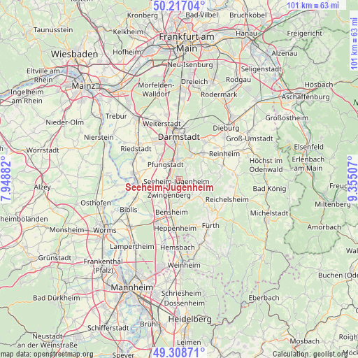
Seeheim-Jugenheim GPS coordinates[2]
49° 45' 54" North, 8° 39' 6.984" East
| Map corner | latitude | longitude |
|---|---|---|
| Upper-left | 50.21704°, | 7.94882° |
| Center: | 49.765°, | 8.65194° |
| Lower-right: | 49.30871°, | 9.35507° |
| Map W x H: | 101×101 km | = 62.8×62.8mi |
| max Lat: | 55.01917° ⇑69.9% North |
| Seeheim-Jugenheim: | 49.765° |
| min Lat: | ⇓30.1% South 47.40724° |
| min Long | Seeheim-Jugenhe | max Long |
| 5.92978° | 8.65194° | 14.98853° |
| W 30.4%⇐ | ⇒69.6% E |
Elevation
Elevation of Seeheim-Jugenheim is 170 m = 558 ft, and this is 79.1 m = 260 ft below average elevation for this country.
| Max E: |
1256 m = 4121 ft | 57.6% |
| Avg. | 249.1 m = 817 ft | |
| Seeheim-Jugenheim | 170 m = 558 ft | |
Min E: |
-5 m = -16 ft | 42.4% |
See also: Germany elevation on elevation.city.
Geographical zone
Seeheim-Jugenheim is located in North temperate zone (between Tropic of Cancer and the Arctic Circle). Distance of this North polar circle is 1867.8 km =1160.6 mi to North.| Distance of | km | miles | from Seeheim-Jugenheim |
|---|---|---|---|
| North Pole | 4473.7 | 2779.8 | to North |
| Arctic Circle | 1867.8 | 1160.6 | to North |
| Tropic Cancer | 2927.4 | 1819 | to South |
| Equator | 5533.3 | 3438.2 | to South |


Nearby cities:
15 places around Seeheim-Jugenheim: (largest is in red/bold)
• Alsbach-Hähnlein
5 km =3.1 mi,  233°
233°
• Bensheim
9.4 km =5.8 mi,  194°
194°
• Bickenbach
2.6 km =1.6 mi,  255°
255°
• Darmstadt
11.9 km =7.4 mi,  359°
359°
• Einhausen
12.3 km =7.6 mi,  217°
217°
• Gernsheim
11.8 km =7.3 mi, 263°
• Griesheim
12.1 km =7.5 mi,  331°
331°
• Groß-Bieberau
13 km =8.1 mi,  72°
72°
• Groß-Rohrheim
13.1 km =8.1 mi,  248°
248°
• Lindenfels
13 km =8.1 mi,  134°
134°
• Lützelbach
8.6 km =5.3 mi,  106°
106°
• Ober-Ramstadt
10.1 km =6.3 mi,  43°
43°
• Pfungstadt
5.7 km =3.5 mi,  322°
322°
• Roßdorf
13.1 km =8.1 mi, 36°
• Zwingenberg
5.4 km =3.4 mi,  212°
212°
Sources, notices
• [Note1] Compared only with cities in Germany existing in our database
• [Src1] Map data: © OpenStreetMap contributors (CC-BY-SA)
• [Src2] Other city data from geonames.org with taken over terms of usage.
• [Src3] Geographical zone / Annual Mean Temperature by Robert A. Rohde @ Wikipedia
