Niederrad geodata
Niederrad (Hesse) is a section of populated place; located in Germany in Europe/Berlin (GMT+2) time zone. With population of 22,370 people, there are 672 cities with bigger population in this country. Compared to other cities in Germany, 61.8% of cities are located further ↑North; 69.9% of cities are located further →East and 68.7% of cities have higher elevation than Niederrad. Note1
Administrative division(s):
- Level 1: Hesse
- Level 2: Regierungsbezirk Darmstadt
- Level 3: Frankfurt am Main
- Level 4: Frankfurt am Main


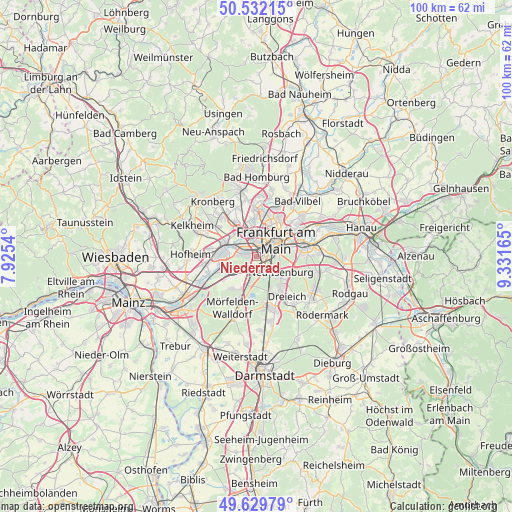
Niederrad GPS coordinates[2]
50° 4' 59.124" North, 8° 37' 42.672" East
| Map corner | latitude | longitude |
|---|---|---|
| Upper-left | 50.53215°, | 7.9254° |
| Center: | 50.08309°, | 8.62852° |
| Lower-right: | 49.62979°, | 9.33165° |
| Map W x H: | 100.3×100.3 km | = 62.3×62.3mi |
| max Lat: | 55.01917° ⇑61.8% North |
| Niederrad: | 50.08309° |
| min Lat: | ⇓38.2% South 47.40724° |
| min Long | Niederrad | max Long |
| 5.92978° | 8.62852° | 14.98853° |
| W 30.1%⇐ | ⇒69.9% E |
Elevation
Elevation of Niederrad is 99 m = 325 ft, and this is 150.1 m = 492 ft below average elevation for this country.
| Max E: |
1256 m = 4121 ft | 68.7% |
| Avg. | 249.1 m = 817 ft | |
| Niederrad | 99 m = 325 ft | |
Min E: |
-5 m = -16 ft | 31.3% |
See also: Germany elevation on elevation.city.
Geographical zone
Niederrad is located in North temperate zone (between Tropic of Cancer and the Arctic Circle). Distance of this North polar circle is 1832.5 km =1138.7 mi to North.| Distance of | km | miles | from Niederrad |
|---|---|---|---|
| North Pole | 4438.3 | 2757.8 | to North |
| Arctic Circle | 1832.5 | 1138.7 | to North |
| Tropic Cancer | 2962.8 | 1841 | to South |
| Equator | 5568.7 | 3460.2 | to South |


Nearby cities:
15 places around Niederrad: (largest is in red/bold)
• Bad Soden am Taunus
10.9 km =6.8 mi,  305°
305°
• Dreieich
8.5 km =5.3 mi,  145°
145°
• Eschborn
7.8 km =4.8 mi,  328°
328°
• Frankfurt am Main
5.4 km =3.4 mi,  47°
47°
• Gallus
1.9 km =1.2 mi,  2°
2°
• Hattersheim
10.9 km =6.8 mi,  267°
267°
• Kelsterbach
7.5 km =4.7 mi,  251°
251°
• Langen
10.8 km =6.7 mi,  164°
164°
• Liederbach
10.5 km =6.5 mi,  294°
294°
• Mörfelden-Walldorf
10.3 km =6.4 mi,  198°
198°
• Neu Isenburg
6.1 km =3.8 mi,  129°
129°
• Offenbach
10 km =6.2 mi,  78°
78°
• Schwalbach am Taunus
10.1 km =6.3 mi,  317°
317°
• Steinbach am Taunus
10.2 km =6.3 mi,  337°
337°
• Sulzbach
9.1 km =5.7 mi, 308°
Sources, notices
• [Note1] Compared only with cities in Germany existing in our database
• [Src1] Map data: © OpenStreetMap contributors (CC-BY-SA)
• [Src2] Other city data from geonames.org with taken over terms of usage.
• [Src3] Geographical zone / Annual Mean Temperature by Robert A. Rohde @ Wikipedia
