Offenbach geodata
Offenbach (Hesse) is a seat of a third-order administrative division; located in Germany in Europe/Berlin (GMT+2) time zone. With population of 119,192 people, there are 79 cities with bigger population in this country. Compared to other cities in Germany, 61.2% of cities are located further ↑North; 68.4% of cities are located further →East and 66.2% of cities have higher elevation than Offenbach. Note1
Administrative division(s):
- Level 1: Hesse
- Level 2: Regierungsbezirk Darmstadt
- Level 3: Kreisfreie Stadt Offenbach am Main
- Level 4: Offenbach am Main


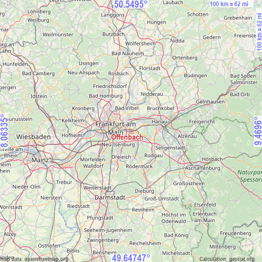
Offenbach GPS coordinates[2]
50° 6' 2.196" North, 8° 45' 59.292" East
| Map corner | latitude | longitude |
|---|---|---|
| Upper-left | 50.5495°, | 8.06335° |
| Center: | 50.10061°, | 8.76647° |
| Lower-right: | 49.64747°, | 9.4696° |
| Map W x H: | 100.3×100.3 km | = 62.3×62.3mi |
| max Lat: | 55.01917° ⇑61.2% North |
| Offenbach: | 50.10061° |
| min Lat: | ⇓38.8% South 47.40724° |
| min Long | Offenbach | max Long |
| 5.92978° | 8.76647° | 14.98853° |
| W 31.6%⇐ | ⇒68.4% E |
Elevation
Elevation of Offenbach is 113 m = 371 ft, and this is 136.1 m = 447 ft below average elevation for this country.
| Max E: |
1256 m = 4121 ft | 66.2% |
| Avg. | 249.1 m = 817 ft | |
| Offenbach | 113 m = 371 ft | |
Min E: |
-5 m = -16 ft | 33.8% |
See also: Offenbach elevation on elevation.city.
Geographical zone
Offenbach is located in North temperate zone (between Tropic of Cancer and the Arctic Circle). Distance of this North polar circle is 1830.5 km =1137.4 mi to North.| Distance of | km | miles | from Offenbach |
|---|---|---|---|
| North Pole | 4436.4 | 2756.7 | to North |
| Arctic Circle | 1830.5 | 1137.4 | to North |
| Tropic Cancer | 2964.7 | 1842.2 | to South |
| Equator | 5570.7 | 3461.5 | to South |


Nearby cities:
15 places around Offenbach: (largest is in red/bold)
• Bad Vilbel
8.9 km =5.5 mi,  346°
346°
• Bruchköbel
14.1 km =8.8 mi,  52°
52°
• Dietzenbach
10.1 km =6.3 mi,  175°
175°
• Dreieich
10.3 km =6.4 mi,  209°
209°
• Frankfurt am Main
6.1 km =3.8 mi,  285°
285°
• Gallus
9.8 km =6.1 mi,  269°
269°
• Hanau am Main
11.2 km =7 mi,  70°
70°
• Heusenstamm
5.6 km =3.5 mi,  153°
153°
• Maintal
7.3 km =4.5 mi,  40°
40°
• Mühlheim am Main
5.1 km =3.2 mi, 69°
• Neu Isenburg
7.8 km =4.8 mi,  221°
221°
• Niederdorfelden
10.7 km =6.6 mi,  12°
12°
• Niederrad
10 km =6.2 mi,  258°
258°
• Obertshausen
6.9 km =4.3 mi,  118°
118°
• Rodgau
11.9 km =7.4 mi,  134°
134°
Sources, notices
• [Note1] Compared only with cities in Germany existing in our database
• [Src1] Map data: © OpenStreetMap contributors (CC-BY-SA)
• [Src2] Other city data from geonames.org with taken over terms of usage.
• [Src3] Geographical zone / Annual Mean Temperature by Robert A. Rohde @ Wikipedia
