Dreieich geodata
Dreieich (Hesse) is a populated place; located in Germany in Europe/Berlin (GMT+2) time zone. With population of 40,367 people, there are 315 cities with bigger population in this country. Compared to other cities in Germany, 63.1% of cities are located further ↑North; 69.1% of cities are located further →East and 62.7% of cities have higher elevation than Dreieich. Note1
Administrative division(s):
- Level 1: Hesse
- Level 2: Regierungsbezirk Darmstadt
- Level 3: Landkreis Offenbach
- Level 4: Dreieich


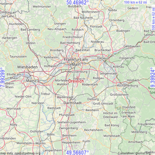
Dreieich GPS coordinates[2]
50° 1' 11.892" North, 8° 41' 45.996" East
| Map corner | latitude | longitude |
|---|---|---|
| Upper-left | 50.46962°, | 7.99299° |
| Center: | 50.01997°, | 8.69611° |
| Lower-right: | 49.56607°, | 9.39924° |
| Map W x H: | 100.5×100.5 km | = 62.4×62.4mi |
| max Lat: | 55.01917° ⇑63.1% North |
| Dreieich: | 50.01997° |
| min Lat: | ⇓36.9% South 47.40724° |
| min Long | Dreieich | max Long |
| 5.92978° | 8.69611° | 14.98853° |
| W 30.9%⇐ | ⇒69.1% E |
Elevation
Elevation of Dreieich is 134 m = 440 ft, and this is 115.1 m = 378 ft below average elevation for this country.
| Max E: |
1256 m = 4121 ft | 62.7% |
| Avg. | 249.1 m = 817 ft | |
| Dreieich | 134 m = 440 ft | |
Min E: |
-5 m = -16 ft | 37.3% |
See also: Dreieich elevation on elevation.city.
Geographical zone
Dreieich is located in North temperate zone (between Tropic of Cancer and the Arctic Circle). Distance of this North polar circle is 1839.5 km =1143 mi to North.| Distance of | km | miles | from Dreieich |
|---|---|---|---|
| North Pole | 4445.4 | 2762.2 | to North |
| Arctic Circle | 1839.5 | 1143 | to North |
| Tropic Cancer | 2955.8 | 1836.6 | to South |
| Equator | 5561.7 | 3455.9 | to South |


Nearby cities:
15 places around Dreieich: (largest is in red/bold)
• Dietzenbach
5.9 km =3.7 mi,  101°
101°
• Egelsbach
6.2 km =3.9 mi,  201°
201°
• Erzhausen
8 km =5 mi,  205°
205°
• Frankfurt am Main
10.7 km =6.6 mi,  355°
355°
• Gallus
10.1 km =6.3 mi,  331°
331°
• Heusenstamm
8.5 km =5.3 mi,  62°
62°
• Kelsterbach
12.8 km =8 mi,  291°
291°
• Langen
3.9 km =2.4 mi, 210°
• Messel
9.6 km =6 mi,  160°
160°
• Mörfelden-Walldorf
8.5 km =5.3 mi,  250°
250°
• Neu Isenburg
3.2 km =2 mi, 357°
• Niederrad
8.5 km =5.3 mi, 325°
• Obertshausen
12.5 km =7.8 mi, 62°
• Offenbach
10.3 km =6.4 mi,  29°
29°
• Rodgau
13.6 km =8.5 mi,  87°
87°
Sources, notices
• [Note1] Compared only with cities in Germany existing in our database
• [Src1] Map data: © OpenStreetMap contributors (CC-BY-SA)
• [Src2] Other city data from geonames.org with taken over terms of usage.
• [Src3] Geographical zone / Annual Mean Temperature by Robert A. Rohde @ Wikipedia
