Gallus geodata
Gallus (Hesse) is a section of populated place; located in Germany in Europe/Berlin (GMT+2) time zone. With population of 39,130 people, there are 333 cities with bigger population in this country. Compared to other cities in Germany, 61.2% of cities are located further ↑North; 69.9% of cities are located further →East and 68.3% of cities have higher elevation than Gallus. Note1
Administrative division(s):
- Level 1: Hesse
- Level 2: Regierungsbezirk Darmstadt
- Level 3: Frankfurt am Main
- Level 4: Frankfurt am Main


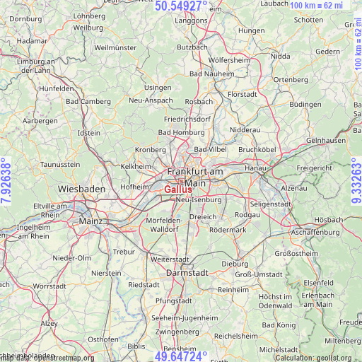
Gallus GPS coordinates[2]
50° 6' 1.368" North, 8° 37' 46.2" East
| Map corner | latitude | longitude |
|---|---|---|
| Upper-left | 50.54927°, | 7.92638° |
| Center: | 50.10038°, | 8.6295° |
| Lower-right: | 49.64724°, | 9.33263° |
| Map W x H: | 100.3×100.3 km | = 62.3×62.3mi |
| max Lat: | 55.01917° ⇑61.2% North |
| Gallus: | 50.10038° |
| min Lat: | ⇓38.8% South 47.40724° |
| min Long | Gallus | max Long |
| 5.92978° | 8.6295° | 14.98853° |
| W 30.1%⇐ | ⇒69.9% E |
Elevation
Elevation of Gallus is 101 m = 331 ft, and this is 148.1 m = 486 ft below average elevation for this country.
| Max E: |
1256 m = 4121 ft | 68.3% |
| Avg. | 249.1 m = 817 ft | |
| Gallus | 101 m = 331 ft | |
Min E: |
-5 m = -16 ft | 31.7% |
See also: Germany elevation on elevation.city.
Geographical zone
Gallus is located in North temperate zone (between Tropic of Cancer and the Arctic Circle). Distance of this North polar circle is 1830.5 km =1137.4 mi to North.| Distance of | km | miles | from Gallus |
|---|---|---|---|
| North Pole | 4436.4 | 2756.7 | to North |
| Arctic Circle | 1830.5 | 1137.4 | to North |
| Tropic Cancer | 2964.7 | 1842.2 | to South |
| Equator | 5570.6 | 3461.4 | to South |


Nearby cities:
15 places around Gallus: (largest is in red/bold)
• Bad Soden am Taunus
10 km =6.2 mi,  296°
296°
• Bad Vilbel
11.6 km =7.2 mi,  41°
41°
• Dreieich
10.1 km =6.3 mi,  151°
151°
• Eschborn
6.3 km =3.9 mi,  318°
318°
• Frankfurt am Main
4.2 km =2.6 mi,  66°
66°
• Hattersheim
11.2 km =7 mi,  257°
257°
• Kelsterbach
8.4 km =5.2 mi,  238°
238°
• Kriftel
11.5 km =7.1 mi, 260°
• Liederbach
10 km =6.2 mi,  284°
284°
• Neu Isenburg
7.4 km =4.6 mi,  141°
141°
• Niederrad
1.9 km =1.2 mi,  182°
182°
• Offenbach
9.8 km =6.1 mi,  89°
89°
• Schwalbach am Taunus
8.8 km =5.5 mi,  308°
308°
• Steinbach am Taunus
8.5 km =5.3 mi,  331°
331°
• Sulzbach
8.1 km =5 mi, 297°
Sources, notices
• [Note1] Compared only with cities in Germany existing in our database
• [Src1] Map data: © OpenStreetMap contributors (CC-BY-SA)
• [Src2] Other city data from geonames.org with taken over terms of usage.
• [Src3] Geographical zone / Annual Mean Temperature by Robert A. Rohde @ Wikipedia
