Fronhausen geodata
Fronhausen (Hesse) is a seat of a fourth-order administrative division; located in Germany in Europe/Berlin (GMT+2) time zone. With population of 4,116 people, there are 3218 cities with bigger population in this country. Compared to other cities in Germany, 52% of cities are located further ↓South; 69.1% of cities are located further →East and 58.1% of cities have higher elevation than Fronhausen. Note1
Administrative division(s):
- Level 1: Hesse
- Level 2: Regierungsbezirk Gießen
- Level 3: Landkreis Marburg-Biedenkopf
- Level 4: Fronhausen


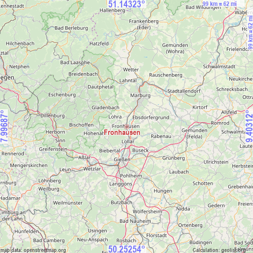
Fronhausen GPS coordinates[2]
50° 42' 0" North, 8° 42' 0" East
| Map corner | latitude | longitude |
|---|---|---|
| Upper-left | 51.14323°, | 7.99687° |
| Center: | 50.7°, | 8.7° |
| Lower-right: | 50.25254°, | 9.40312° |
| Map W x H: | 99×99 km | = 61.5×61.5mi |
| max Lat: | 55.01917° ⇑48% North |
| Fronhausen: | 50.7° |
| min Lat: | ⇓52% South 47.40724° |
| min Long | Fronhausen | max Long |
| 5.92978° | 8.7° | 14.98853° |
| W 30.9%⇐ | ⇒69.1% E |
Elevation
Elevation of Fronhausen is 167 m = 548 ft, and this is 82.1 m = 269 ft below average elevation for this country.
| Max E: |
1256 m = 4121 ft | 58.1% |
| Avg. | 249.1 m = 817 ft | |
| Fronhausen | 167 m = 548 ft | |
Min E: |
-5 m = -16 ft | 41.9% |
See also: Germany elevation on elevation.city.
Geographical zone
Fronhausen is located in North temperate zone (between Tropic of Cancer and the Arctic Circle). Distance of this North polar circle is 1763.9 km =1096 mi to North.| Distance of | km | miles | from Fronhausen |
|---|---|---|---|
| North Pole | 4369.8 | 2715.3 | to North |
| Arctic Circle | 1763.9 | 1096 | to North |
| Tropic Cancer | 3031.4 | 1883.6 | to South |
| Equator | 5637.3 | 3502.9 | to South |


Nearby cities:
15 places around Fronhausen: (largest is in red/bold)
• Alten Buseck
9.4 km =5.8 mi,  156°
156°
• Bad Endbach
15.1 km =9.4 mi,  291°
291°
• Beuern
11.7 km =7.3 mi,  133°
133°
• Ebsdorfergrund
11.4 km =7.1 mi,  75°
75°
• Gießen
12.7 km =7.9 mi,  187°
187°
• Gladenbach
11.3 km =7 mi,  312°
312°
• Großen Buseck
12.1 km =7.5 mi,  150°
150°
• Heuchelheim
13.8 km =8.6 mi,  199°
199°
• Lohra
6 km =3.7 mi, 308°
• Lollar
6 km =3.7 mi,  176°
176°
• Marburg an der Lahn
13.1 km =8.1 mi,  22°
22°
• Rabenau
11.8 km =7.3 mi,  102°
102°
• Reiskirchen
14.6 km =9.1 mi,  139°
139°
• Staufenberg
4.8 km =3 mi, 152°
• Trohe
10.7 km =6.6 mi, 159°
Sources, notices
• [Note1] Compared only with cities in Germany existing in our database
• [Src1] Map data: © OpenStreetMap contributors (CC-BY-SA)
• [Src2] Other city data from geonames.org with taken over terms of usage.
• [Src3] Geographical zone / Annual Mean Temperature by Robert A. Rohde @ Wikipedia
