Großen Buseck geodata
Großen Buseck (Hesse) is a seat of a fourth-order administrative division; located in Germany in Europe/Berlin (GMT+2) time zone. In our database, there are 11009 cities with bigger population. Compared to other cities in Germany, 50.4% of cities are located further ↑North; 68.1% of cities are located further →East and 54.2% of cities have higher elevation than Großen Buseck. Note1
Administrative division(s):
- Level 1: Hesse
- Level 2: Regierungsbezirk Gießen
- Level 3: Landkreis Gießen
- Level 4: Buseck


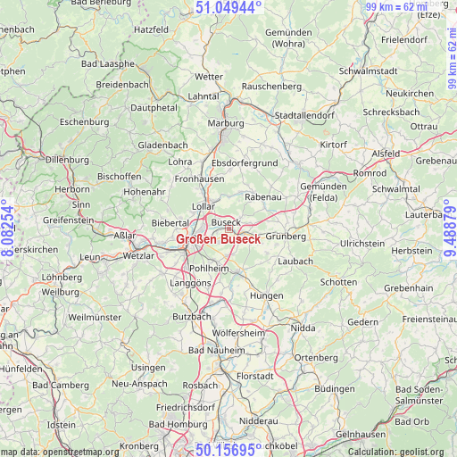
Großen Buseck GPS coordinates[2]
50° 36' 19.116" North, 8° 47' 8.376" East
| Map corner | latitude | longitude |
|---|---|---|
| Upper-left | 51.04944°, | 8.08254° |
| Center: | 50.60531°, | 8.78566° |
| Lower-right: | 50.15695°, | 9.48879° |
| Map W x H: | 99.2×99.2 km | = 61.6×61.6mi |
| max Lat: | 55.01917° ⇑50.4% North |
| Großen Buseck: | 50.60531° |
| min Lat: | ⇓49.6% South 47.40724° |
| min Long | Großen Buseck | max Long |
| 5.92978° | 8.78566° | 14.98853° |
| W 31.9%⇐ | ⇒68.1% E |
Elevation
Elevation of Großen Buseck is 195 m = 640 ft, and this is 54.1 m = 177 ft below average elevation for this country.
| Max E: |
1256 m = 4121 ft | 54.2% |
| Avg. | 249.1 m = 817 ft | |
| Großen Buseck | 195 m = 640 ft | |
Min E: |
-5 m = -16 ft | 45.8% |
See also: Germany elevation on elevation.city.
Geographical zone
Großen Buseck is located in North temperate zone (between Tropic of Cancer and the Arctic Circle). Distance of this North polar circle is 1774.4 km =1102.6 mi to North.| Distance of | km | miles | from Großen Buseck |
|---|---|---|---|
| North Pole | 4380.3 | 2721.8 | to North |
| Arctic Circle | 1774.4 | 1102.6 | to North |
| Tropic Cancer | 3020.9 | 1877.1 | to South |
| Equator | 5626.8 | 3496.3 | to South |


Nearby cities:
15 places around Großen Buseck: (largest is in red/bold)
• Allendorf an der Lahn
13.2 km =8.2 mi,  242°
242°
• Alten Buseck
3 km =1.9 mi,  309°
309°
• Beuern
3.5 km =2.2 mi,  45°
45°
• Ebsdorfergrund
14.3 km =8.9 mi,  20°
20°
• Fronhausen
12.1 km =7.5 mi,  330°
330°
• Gießen
8 km =5 mi,  255°
255°
• Grünberg
12.3 km =7.6 mi,  95°
95°
• Heuchelheim
11 km =6.8 mi, 257°
• Langgöns
14.4 km =8.9 mi,  215°
215°
• Lich
9.6 km =6 mi,  167°
167°
• Lollar
7.3 km =4.5 mi, 308°
• Rabenau
9.8 km =6.1 mi,  34°
34°
• Reiskirchen
3.4 km =2.1 mi, 99°
• Staufenberg
7.4 km =4.6 mi, 328°
• Trohe
2.4 km =1.5 mi,  282°
282°
Sources, notices
• [Note1] Compared only with cities in Germany existing in our database
• [Src1] Map data: © OpenStreetMap contributors (CC-BY-SA)
• [Src2] Other city data from geonames.org with taken over terms of usage.
• [Src3] Geographical zone / Annual Mean Temperature by Robert A. Rohde @ Wikipedia
