Prenzlauer Berg geodata
Prenzlauer Berg (Berlin) is a section of populated place; located in Germany in Europe/Berlin (GMT+2) time zone. With population of 148,878 people, there are 61 cities with bigger population in this country. Compared to other cities in Germany, 77.9% of cities are located further ↓South; 95.3% of cities are located further ←West and 77.5% of cities have higher elevation than Prenzlauer Berg. Note1


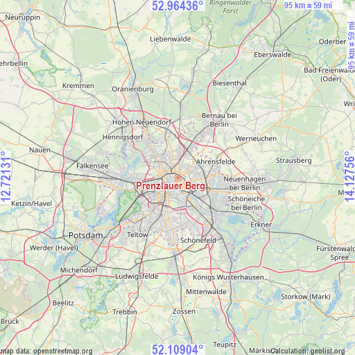
Prenzlauer Berg GPS coordinates[2]
52° 32' 19.608" North, 13° 25' 27.948" East
| Map corner | latitude | longitude |
|---|---|---|
| Upper-left | 52.96436°, | 12.72131° |
| Center: | 52.53878°, | 13.42443° |
| Lower-right: | 52.10904°, | 14.12756° |
| Map W x H: | 95.1×95.1 km | = 59.1×59.1mi |
| max Lat: | 55.01917° ⇑22.1% North |
| Prenzlauer Berg: | 52.53878° |
| min Lat: | ⇓77.9% South 47.40724° |
| min Long | Prenzlauer Berg | max Long |
| 5.92978° | 13.42443° | 14.98853° |
| W 95.3%⇐ | ⇒4.7% E |
Elevation
Elevation of Prenzlauer Berg is 54 m = 177 ft, and this is 195.1 m = 640 ft below average elevation for this country.
| Max E: |
1256 m = 4121 ft | 77.5% |
| Avg. | 249.1 m = 817 ft | |
| Prenzlauer Berg | 54 m = 177 ft | |
Min E: |
-5 m = -16 ft | 22.5% |
See also: Prenzlauer Berg elevation on elevation.city.
Geographical zone
Prenzlauer Berg is located in North temperate zone (between Tropic of Cancer and the Arctic Circle). Distance of this North polar circle is 1559.4 km =969 mi to North.| Distance of | km | miles | from Prenzlauer Berg |
|---|---|---|---|
| North Pole | 4165.3 | 2588.2 | to North |
| Arctic Circle | 1559.4 | 969 | to North |
| Tropic Cancer | 3235.8 | 2010.6 | to South |
| Equator | 5841.8 | 3629.9 | to South |


Nearby cities:
15 places around Prenzlauer Berg: (largest is in red/bold)
• Alt-Hohenschönhausen
5.3 km =3.3 mi,  81°
81°
• Berlin
1.9 km =1.2 mi,  210°
210°
• Berlin Treptow
5.2 km =3.2 mi,  164°
164°
• Fennpfuhl
3.4 km =2.1 mi,  108°
108°
• Friedrichshain
3.3 km =2.1 mi,  141°
141°
• Gesundbrunnen
2.6 km =1.6 mi,  299°
299°
• Heinersdorf
3.8 km =2.4 mi,  13°
13°
• Kreuzberg
4.6 km =2.9 mi,  198°
198°
• Lichtenberg
5.8 km =3.6 mi,  118°
118°
• Mitte
2.5 km =1.6 mi, 212°
• Niederschönhausen
5.3 km =3.3 mi,  344°
344°
• Pankow
3.7 km =2.3 mi, 335°
• Tiergarten
4.6 km =2.9 mi,  237°
237°
• Wedding
4.7 km =2.9 mi,  281°
281°
• Weißensee
3.4 km =2.1 mi,  55°
55°
In other languages:
- In France: Berlin-Prenzlauer Berg
- In German: Berlin-Prenzlauer Berg
- In Russian: Пренцлауэр-Берг
- In Chinese: 普伦茨劳贝格
Sources, notices
• [Note1] Compared only with cities in Germany existing in our database
• [Src1] Map data: © OpenStreetMap contributors (CC-BY-SA)
• [Src2] Other city data from geonames.org with taken over terms of usage.
• [Src3] Geographical zone / Annual Mean Temperature by Robert A. Rohde @ Wikipedia
