Simmozheim geodata
Simmozheim (Baden-Württemberg) is a seat of a fourth-order administrative division; located in Germany in Europe/Berlin (GMT+2) time zone. With population of 2,731 people, there are 4207 cities with bigger population in this country. Compared to other cities in Germany, 85.9% of cities are located further ↑North; 67.8% of cities are located further →East and 86.2% of cities have lower elevation than Simmozheim. Note1
Administrative division(s):
- Level 1: Baden-Württemberg
- Level 2: Karlsruhe Region
- Level 3: Landkreis Calw
- Level 4: Simmozheim


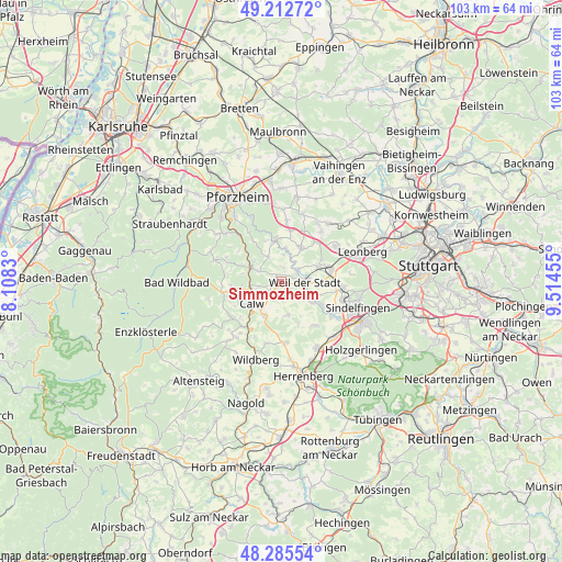
Simmozheim GPS coordinates[2]
48° 45' 4.572" North, 8° 48' 41.112" East
| Map corner | latitude | longitude |
|---|---|---|
| Upper-left | 49.21272°, | 8.1083° |
| Center: | 48.75127°, | 8.81142° |
| Lower-right: | 48.28554°, | 9.51455° |
| Map W x H: | 103.1×103.1 km | = 64.1×64.1mi |
| max Lat: | 55.01917° ⇑85.9% North |
| Simmozheim: | 48.75127° |
| min Lat: | ⇓14.1% South 47.40724° |
| min Long | Simmozheim | max Long |
| 5.92978° | 8.81142° | 14.98853° |
| W 32.2%⇐ | ⇒67.8% E |
Elevation
Elevation of Simmozheim is 479 m = 1572 ft, and this is 229.9 m = 754 ft above average elevation for this country.
| Max E: |
1256 m = 4121 ft | 13.8% |
| Simmozheim | 479 m 1572 ft | |
| Avg. | 249.1 m = 817 ft | |
Min E: |
-5 m = -16 ft | 86.2% |
See also: Germany elevation on elevation.city.
Geographical zone
Simmozheim is located in North temperate zone (between Tropic of Cancer and the Arctic Circle). Distance of this North polar circle is 1980.5 km =1230.6 mi to North.| Distance of | km | miles | from Simmozheim |
|---|---|---|---|
| North Pole | 4586.4 | 2849.9 | to North |
| Arctic Circle | 1980.5 | 1230.6 | to North |
| Tropic Cancer | 2814.7 | 1749 | to South |
| Equator | 5420.6 | 3368.2 | to South |


Nearby cities:
15 places around Simmozheim: (largest is in red/bold)
• Aidlingen
10.2 km =6.3 mi,  142°
142°
• Althengstett
3.4 km =2.1 mi,  201°
201°
• Bad Liebenzell
6.5 km =4 mi,  293°
293°
• Bad Teinach-Zavelstein
11 km =6.8 mi,  232°
232°
• Calw
6.6 km =4.1 mi, 231°
• Friolzheim
9.3 km =5.8 mi,  9°
9°
• Gechingen
6.4 km =4 mi,  168°
168°
• Grafenau
8.5 km =5.3 mi,  119°
119°
• Heimsheim
7.4 km =4.6 mi,  33°
33°
• Neuhausen
5.3 km =3.3 mi,  330°
330°
• Oberreichenbach
10.8 km =6.7 mi,  259°
259°
• Ostelsheim
3.9 km =2.4 mi, 135°
• Renningen
9.6 km =6 mi,  77°
77°
• Tiefenbronn
8.1 km =5 mi,  354°
354°
• Weil der Stadt
4.4 km =2.7 mi,  92°
92°
Sources, notices
• [Note1] Compared only with cities in Germany existing in our database
• [Src1] Map data: © OpenStreetMap contributors (CC-BY-SA)
• [Src2] Other city data from geonames.org with taken over terms of usage.
• [Src3] Geographical zone / Annual Mean Temperature by Robert A. Rohde @ Wikipedia
