Vipperød geodata
Vipperød (Zealand) is a populated place; located in Denmark in Europe/Copenhagen (GMT+2) time zone. With population of 2,345 people, there are 270 cities with bigger population in this country. Compared to other cities in Denmark, 55% of cities are located further ↑North; 69.6% of cities are located further ←West and 64.9% of cities have lower elevation than Vipperød. Note1


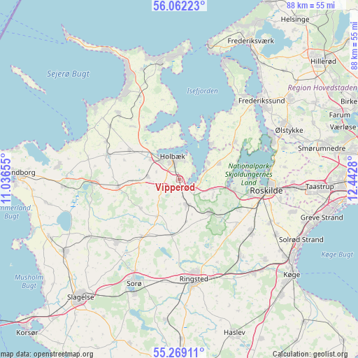
Vipperød GPS coordinates[2]
55° 40' 3.648" North, 11° 44' 22.812" East
| Map corner | latitude | longitude |
|---|---|---|
| Upper-left | 56.06223°, | 11.03655° |
| Center: | 55.66768°, | 11.73967° |
| Lower-right: | 55.26911°, | 12.4428° |
| Map W x H: | 88.2×88.2 km | = 54.8×54.8mi |
| max Lat: | 57.72093° ⇑55% North |
| Vipperød: | 55.66768° |
| min Lat: | ⇓45% South 54.57644° |
| min Long | Vipperød | max Long |
| 8.12605° | 11.73967° | 15.18662° |
| W 69.6%⇐ | ⇒30.4% E |
Elevation
Elevation of Vipperød is 32 m = 105 ft, and this is 4.7 m = 15 ft above average elevation for this country.
| Max E: |
114 m = 374 ft | 35.1% |
| Vipperød | 32 m 105 ft | |
| Avg. | 27.3 m = 90 ft | |
Min E: |
0 m = 0 ft | 64.9% |
See also: Denmark elevation on elevation.city.
Geographical zone
Vipperød is located in North temperate zone (between Tropic of Cancer and the Arctic Circle). Distance of this North polar circle is 1211.5 km =752.8 mi to North.| Distance of | km | miles | from Vipperød |
|---|---|---|---|
| North Pole | 3817.4 | 2372 | to North |
| Arctic Circle | 1211.5 | 752.8 | to North |
| Tropic Cancer | 3583.7 | 2226.8 | to South |
| Equator | 6189.7 | 3846.1 | to South |


Nearby cities:
15 places around Vipperød: (largest is in red/bold)
• Asnæs
21.9 km =13.6 mi,  317°
317°
• Dianalund
21.7 km =13.5 mi,  225°
225°
• Ejby
7.2 km =4.5 mi,  70°
70°
• Holbæk
5.8 km =3.6 mi,  343°
343°
• Hørve
20.3 km =12.6 mi,  297°
297°
• Jyderup
20 km =12.4 mi,  268°
268°
• Kirke Hvalsø
11.4 km =7.1 mi,  137°
137°
• Lejre
16.3 km =10.1 mi,  115°
115°
• Osted
18 km =11.2 mi,  130°
130°
• Roskilde
21.6 km =13.4 mi,  97°
97°
• Skibby
16.7 km =10.4 mi,  56°
56°
• Stenlille
17.1 km =10.6 mi,  213°
213°
• Svinninge
18.2 km =11.3 mi,  289°
289°
• Svogerslev
17.6 km =10.9 mi, 102°
• Tølløse
6.4 km =4 mi,  162°
162°
Sources, notices
• [Note1] Compared only with cities in Denmark existing in our database
• [Src1] Map data: © OpenStreetMap contributors (CC-BY-SA)
• [Src2] Other city data from geonames.org with taken over terms of usage.
• [Src3] Geographical zone / Annual Mean Temperature by Robert A. Rohde @ Wikipedia
