Jyderup geodata
Jyderup (Zealand) is a populated place; located in Denmark in Europe/Copenhagen (GMT+2) time zone. With population of 3,984 people, there are 160 cities with bigger population in this country. Compared to other cities in Denmark, 55.8% of cities are located further ↑North; 65.2% of cities are located further ←West and 57.9% of cities have lower elevation than Jyderup. Note1


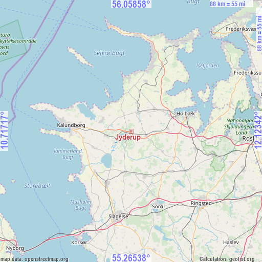
Jyderup GPS coordinates[2]
55° 39' 50.364" North, 11° 25' 13.044" East
| Map corner | latitude | longitude |
|---|---|---|
| Upper-left | 56.05858°, | 10.71717° |
| Center: | 55.66399°, | 11.42029° |
| Lower-right: | 55.26538°, | 12.12342° |
| Map W x H: | 88.2×88.2 km | = 54.8×54.8mi |
| max Lat: | 57.72093° ⇑55.8% North |
| Jyderup: | 55.66399° |
| min Lat: | ⇓44.2% South 54.57644° |
| min Long | Jyderup | max Long |
| 8.12605° | 11.42029° | 15.18662° |
| W 65.2%⇐ | ⇒34.8% E |
Elevation
Elevation of Jyderup is 28 m = 92 ft, and this is 0.7 m = 2 ft above average elevation for this country.
| Max E: |
114 m = 374 ft | 42.1% |
| Jyderup | 28 m 92 ft | |
| Avg. | 27.3 m = 90 ft | |
Min E: |
0 m = 0 ft | 57.9% |
See also: Denmark elevation on elevation.city.
Geographical zone
Jyderup is located in North temperate zone (between Tropic of Cancer and the Arctic Circle). Distance of this North polar circle is 1211.9 km =753 mi to North.| Distance of | km | miles | from Jyderup |
|---|---|---|---|
| North Pole | 3817.8 | 2372.3 | to North |
| Arctic Circle | 1211.9 | 753 | to North |
| Tropic Cancer | 3583.3 | 2226.6 | to South |
| Equator | 6189.3 | 3845.9 | to South |


Nearby cities:
15 places around Jyderup: (largest is in red/bold)
• Asnæs
17.3 km =10.7 mi,  17°
17°
• Dianalund
15.4 km =9.6 mi,  162°
162°
• Ejby
26.9 km =16.7 mi,  84°
84°
• Gørlev
18.4 km =11.4 mi,  221°
221°
• Holbæk
19.3 km =12 mi,  72°
72°
• Høng
19.3 km =12 mi,  205°
205°
• Hørve
10.1 km =6.3 mi,  11°
11°
• Kalundborg
20.9 km =13 mi,  274°
274°
• Kirke Hvalsø
28.9 km =18 mi,  106°
106°
• Sorø
27.2 km =16.9 mi, 161°
• Stenlille
17.6 km =10.9 mi,  142°
142°
• Svebølle
8.5 km =5.3 mi,  260°
260°
• Svinninge
7 km =4.3 mi, 24°
• Tølløse
22.7 km =14.1 mi,  104°
104°
• Vipperød
20 km =12.4 mi,  88°
88°
Sources, notices
• [Note1] Compared only with cities in Denmark existing in our database
• [Src1] Map data: © OpenStreetMap contributors (CC-BY-SA)
• [Src2] Other city data from geonames.org with taken over terms of usage.
• [Src3] Geographical zone / Annual Mean Temperature by Robert A. Rohde @ Wikipedia
