Dianalund geodata
Dianalund (Zealand) is a populated place; located in Denmark in Europe/Copenhagen (GMT+2) time zone. With population of 3,605 people, there are 178 cities with bigger population in this country. Compared to other cities in Denmark, 65.8% of cities are located further ↑North; 66.4% of cities are located further ←West and 57.9% of cities have lower elevation than Dianalund. Note1


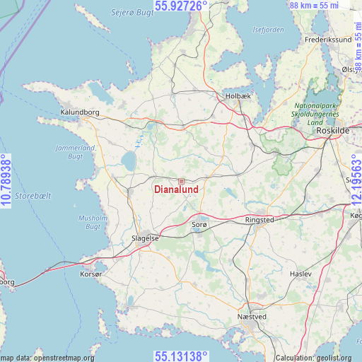
Dianalund GPS coordinates[2]
55° 31' 52.788" North, 11° 29' 33" East
| Map corner | latitude | longitude |
|---|---|---|
| Upper-left | 55.92726°, | 10.78938° |
| Center: | 55.53133°, | 11.4925° |
| Lower-right: | 55.13138°, | 12.19563° |
| Map W x H: | 88.5×88.5 km | = 55×55mi |
| max Lat: | 57.72093° ⇑65.8% North |
| Dianalund: | 55.53133° |
| min Lat: | ⇓34.2% South 54.57644° |
| min Long | Dianalund | max Long |
| 8.12605° | 11.4925° | 15.18662° |
| W 66.4%⇐ | ⇒33.6% E |
Elevation
Elevation of Dianalund is 28 m = 92 ft, and this is 0.7 m = 2 ft above average elevation for this country.
| Max E: |
114 m = 374 ft | 42.1% |
| Dianalund | 28 m 92 ft | |
| Avg. | 27.3 m = 90 ft | |
Min E: |
0 m = 0 ft | 57.9% |
See also: Denmark elevation on elevation.city.
Geographical zone
Dianalund is located in North temperate zone (between Tropic of Cancer and the Arctic Circle). Distance of this North polar circle is 1226.7 km =762.2 mi to North.| Distance of | km | miles | from Dianalund |
|---|---|---|---|
| North Pole | 3832.6 | 2381.5 | to North |
| Arctic Circle | 1226.7 | 762.2 | to North |
| Tropic Cancer | 3568.6 | 2217.4 | to South |
| Equator | 6174.5 | 3836.7 | to South |


Nearby cities:
15 places around Dianalund: (largest is in red/bold)
• Forlev
22.8 km =14.2 mi,  220°
220°
• Frederiksberg
13.7 km =8.5 mi,  159°
159°
• Gørlev
16.7 km =10.4 mi,  273°
273°
• Høng
13.1 km =8.1 mi,  258°
258°
• Hørve
24.8 km =15.4 mi,  354°
354°
• Jyderup
15.4 km =9.6 mi,  342°
342°
• Kirke Hvalsø
24.2 km =15 mi,  73°
73°
• Ringsted
21.2 km =13.2 mi,  117°
117°
• Slagelse
16.7 km =10.4 mi,  211°
211°
• Sorø
11.8 km =7.3 mi, 160°
• Stenlille
6.3 km =3.9 mi,  82°
82°
• Svebølle
18.6 km =11.6 mi,  316°
316°
• Svinninge
21.2 km =13.2 mi,  355°
355°
• Tølløse
19.7 km =12.2 mi,  62°
62°
• Vipperød
21.7 km =13.5 mi,  45°
45°
Sources, notices
• [Note1] Compared only with cities in Denmark existing in our database
• [Src1] Map data: © OpenStreetMap contributors (CC-BY-SA)
• [Src2] Other city data from geonames.org with taken over terms of usage.
• [Src3] Geographical zone / Annual Mean Temperature by Robert A. Rohde @ Wikipedia
