Tølløse geodata
Tølløse (Zealand) is a populated place; located in Denmark in Europe/Copenhagen (GMT+2) time zone. With population of 3,457 people, there are 183 cities with bigger population in this country. Compared to other cities in Denmark, 60.8% of cities are located further ↑North; 70.2% of cities are located further ←West and 81% of cities have lower elevation than Tølløse. Note1


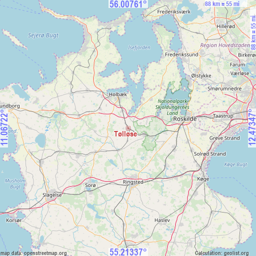
Tølløse GPS coordinates[2]
55° 36' 45" North, 11° 46' 13.224" East
| Map corner | latitude | longitude |
|---|---|---|
| Upper-left | 56.00761°, | 11.06722° |
| Center: | 55.6125°, | 11.77034° |
| Lower-right: | 55.21337°, | 12.47347° |
| Map W x H: | 88.3×88.3 km | = 54.9×54.9mi |
| max Lat: | 57.72093° ⇑60.8% North |
| Tølløse: | 55.6125° |
| min Lat: | ⇓39.2% South 54.57644° |
| min Long | Tølløse | max Long |
| 8.12605° | 11.77034° | 15.18662° |
| W 70.2%⇐ | ⇒29.8% E |
Elevation
Elevation of Tølløse is 47 m = 154 ft, and this is 19.7 m = 65 ft above average elevation for this country.
| Max E: |
114 m = 374 ft | 19% |
| Tølløse | 47 m 154 ft | |
| Avg. | 27.3 m = 90 ft | |
Min E: |
0 m = 0 ft | 81% |
See also: Denmark elevation on elevation.city.
Geographical zone
Tølløse is located in North temperate zone (between Tropic of Cancer and the Arctic Circle). Distance of this North polar circle is 1217.6 km =756.6 mi to North.| Distance of | km | miles | from Tølløse |
|---|---|---|---|
| North Pole | 3823.5 | 2375.8 | to North |
| Arctic Circle | 1217.6 | 756.6 | to North |
| Tropic Cancer | 3577.6 | 2223 | to South |
| Equator | 6183.5 | 3842.2 | to South |


Nearby cities:
15 places around Tølløse: (largest is in red/bold)
• Borup
18.4 km =11.4 mi,  135°
135°
• Dianalund
19.7 km =12.2 mi,  242°
242°
• Ejby
9.8 km =6.1 mi,  29°
29°
• Holbæk
12.2 km =7.6 mi,  342°
342°
• Kirke Hvalsø
6.2 km =3.9 mi,  111°
111°
• Lejre
12.9 km =8 mi,  93°
93°
• Osted
13 km =8.1 mi,  115°
115°
• Ringsted
18.9 km =11.7 mi,  176°
176°
• Roskilde
19.7 km =12.2 mi,  80°
80°
• Skibby
19.5 km =12.1 mi,  37°
37°
• Stenlille
13.9 km =8.6 mi,  233°
233°
• Svinninge
22.6 km =14 mi,  302°
302°
• Svogerslev
15.5 km =9.6 mi, 81°
• Viby
17.4 km =10.8 mi, 113°
• Vipperød
6.4 km =4 mi, 342°
Sources, notices
• [Note1] Compared only with cities in Denmark existing in our database
• [Src1] Map data: © OpenStreetMap contributors (CC-BY-SA)
• [Src2] Other city data from geonames.org with taken over terms of usage.
• [Src3] Geographical zone / Annual Mean Temperature by Robert A. Rohde @ Wikipedia
