Vanløse geodata
Vanløse (Capital Region) is a section of populated place; located in Denmark in Europe/Copenhagen (GMT+2) time zone. With population of 37,115 people, there are 18 cities with bigger population in this country. Compared to other cities in Denmark, 53.2% of cities are located further ↑North; 93.9% of cities are located further ←West and 67% of cities have higher elevation than Vanløse. Note1


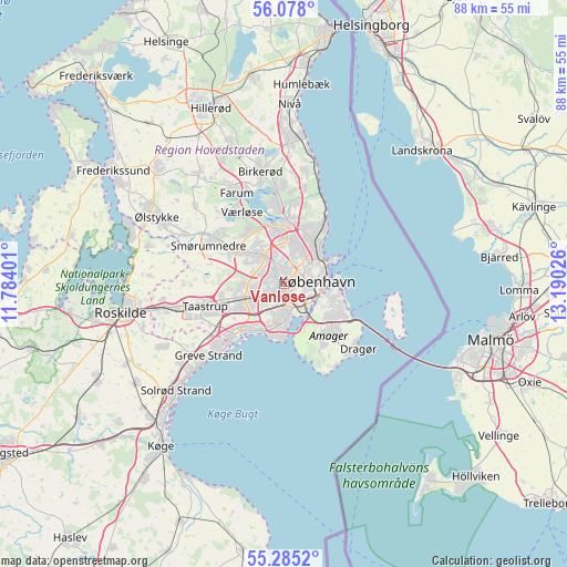
Vanløse GPS coordinates[2]
55° 41' 0.996" North, 12° 29' 13.668" East
| Map corner | latitude | longitude |
|---|---|---|
| Upper-left | 56.078°, | 11.78401° |
| Center: | 55.68361°, | 12.48713° |
| Lower-right: | 55.2852°, | 13.19026° |
| Map W x H: | 88.2×88.1 km | = 54.8×54.7mi |
| max Lat: | 57.72093° ⇑53.2% North |
| Vanløse: | 55.68361° |
| min Lat: | ⇓46.8% South 54.57644° |
| min Long | Vanløse | max Long |
| 8.12605° | 12.48713° | 15.18662° |
| W 93.9%⇐ | ⇒6.1% E |
Elevation
Elevation of Vanløse is 14 m = 46 ft, and this is 13.3 m = 44 ft below average elevation for this country.
| Max E: |
114 m = 374 ft | 67% |
| Avg. | 27.3 m = 90 ft | |
| Vanløse | 14 m = 46 ft | |
Min E: |
0 m = 0 ft | 33% |
See also: Denmark elevation on elevation.city.
Geographical zone
Vanløse is located in North temperate zone (between Tropic of Cancer and the Arctic Circle). Distance of this North polar circle is 1209.7 km =751.7 mi to North.| Distance of | km | miles | from Vanløse |
|---|---|---|---|
| North Pole | 3815.6 | 2370.9 | to North |
| Arctic Circle | 1209.7 | 751.7 | to North |
| Tropic Cancer | 3585.5 | 2227.9 | to South |
| Equator | 6191.4 | 3847.2 | to South |


Nearby cities:
15 places around Vanløse: (largest is in red/bold)
• Albertslund
8.3 km =5.2 mi,  248°
248°
• Ballerup
9.4 km =5.8 mi,  304°
304°
• Brøndbyvester
6.4 km =4 mi,  228°
228°
• Buddinge
7.2 km =4.5 mi,  4°
4°
• Charlottenlund
9.4 km =5.8 mi,  35°
35°
• Christianshavn
6.9 km =4.3 mi,  99°
99°
• Copenhagen
5 km =3.1 mi, 99°
• Frederiksberg
3 km =1.9 mi, 98°
• Glostrup
5.6 km =3.5 mi, 250°
• Herlev
5.3 km =3.3 mi,  326°
326°
• Hvidovre
3.1 km =1.9 mi,  196°
196°
• Rødovre
2.1 km =1.3 mi,  260°
260°
• Tårnby
9.3 km =5.8 mi,  129°
129°
• Vallensbæk
9.4 km =5.8 mi,  223°
223°
• Vibekevang
4.9 km =3 mi,  60°
60°
Sources, notices
• [Note1] Compared only with cities in Denmark existing in our database
• [Src1] Map data: © OpenStreetMap contributors (CC-BY-SA)
• [Src2] Other city data from geonames.org with taken over terms of usage.
• [Src3] Geographical zone / Annual Mean Temperature by Robert A. Rohde @ Wikipedia
