Charlottenlund geodata
Charlottenlund (Capital Region) is a seat of a second-order administrative division; located in Denmark in Europe/Copenhagen (GMT+2) time zone. With population of 40,000 people, there are 16 cities with bigger population in this country. Compared to other cities in Denmark, 50.9% of cities are located further ↓South; 97.7% of cities are located further ←West and 67% of cities have higher elevation than Charlottenlund. Note1


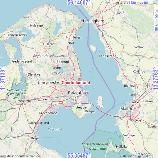
Charlottenlund GPS coordinates[2]
55° 45' 8.568" North, 12° 34' 28.2" East
| Map corner | latitude | longitude |
|---|---|---|
| Upper-left | 56.14607°, | 11.87138° |
| Center: | 55.75238°, | 12.5745° |
| Lower-right: | 55.35467°, | 13.27763° |
| Map W x H: | 88×88 km | = 54.7×54.7mi |
| max Lat: | 57.72093° ⇑49.1% North |
| Charlottenlund: | 55.75238° |
| min Lat: | ⇓50.9% South 54.57644° |
| min Long | Charlottenlund | max Long |
| 8.12605° | 12.5745° | 15.18662° |
| W 97.7%⇐ | ⇒2.3% E |
Elevation
Elevation of Charlottenlund is 14 m = 46 ft, and this is 13.3 m = 44 ft below average elevation for this country.
| Max E: |
114 m = 374 ft | 67% |
| Avg. | 27.3 m = 90 ft | |
| Charlottenlund | 14 m = 46 ft | |
Min E: |
0 m = 0 ft | 33% |
See also: Charlottenlund elevation on elevation.city.
Geographical zone
Charlottenlund is located in North temperate zone (between Tropic of Cancer and the Arctic Circle). Distance of this North polar circle is 1202.1 km =747 mi to North.| Distance of | km | miles | from Charlottenlund |
|---|---|---|---|
| North Pole | 3808 | 2366.2 | to North |
| Arctic Circle | 1202.1 | 747 | to North |
| Tropic Cancer | 3593.2 | 2232.7 | to South |
| Equator | 6199.1 | 3851.9 | to South |


Nearby cities:
15 places around Charlottenlund: (largest is in red/bold)
• Ballerup
13.4 km =8.3 mi,  260°
260°
• Buddinge
5 km =3.1 mi, 264°
• Christianshavn
8.8 km =5.5 mi,  171°
171°
• Copenhagen
8.5 km =5.3 mi,  183°
183°
• Frederiksberg
8.5 km =5.3 mi,  197°
197°
• Herlev
9 km =5.6 mi,  249°
249°
• Holte
9.8 km =6.1 mi,  316°
316°
• Hvidovre
12.3 km =7.6 mi,  210°
210°
• Kongens Lyngby
4.9 km =3 mi,  294°
294°
• Rødovre
11 km =6.8 mi,  223°
223°
• Stavnsholt
12.6 km =7.8 mi,  303°
303°
• Trørød
9.9 km =6.2 mi,  348°
348°
• Vanløse
9.4 km =5.8 mi, 215°
• Vibekevang
5.3 km =3.3 mi,  192°
192°
• Værløse
13.3 km =8.3 mi,  284°
284°
Sources, notices
• [Note1] Compared only with cities in Denmark existing in our database
• [Src1] Map data: © OpenStreetMap contributors (CC-BY-SA)
• [Src2] Other city data from geonames.org with taken over terms of usage.
• [Src3] Geographical zone / Annual Mean Temperature by Robert A. Rohde @ Wikipedia
